- Data Basin |
- Datasets |
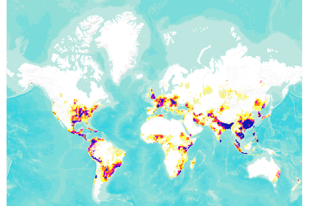
- Global Flood Hazard Frequency and Distribution
Global Flood Hazard Frequency and Distribution
Mar 4, 2011
(Last modified Mar 8, 2011)
Uploaded by
Conservation Biology Institute
- Description:
- Global Flood Hazard Frequency and Distribution is a 2.5 by 2.5 minute grid derived from a global listing of extreme flood events between 1985 and 2003 (poor or missing data in the early/mid 1990s) compiled by Dartmouth Flood Observatory and georeferenced to the nearest degree. The resultant flood frequency grid was then classified into 10 classes of approximately equal number of grid cells. The greater the grid cell value in the final data set, the higher the relative frequency of flood occurrence. The dataset is a result of the collaboration among the Center for Hazards and Risk Research (CHRR) , and the Columbia University Center for International Earth Science Information Network (CIESIN).If you wish to download this data, please visit http://www.ldeo.columbia.edu/chrr/research/hotspots/coredata.html.
- Data Provided By:
- Center for Hazards and Risk Research (CHRR); Center for International Earth Science Information Network (CIESIN), Columbia University
- Content date:
- 1985-2003
- Citation:
-
Global Flood Hazard Frequency and Distribution. 2005. Center for Hazards and Risks Research (CHRR), Columbia University; Center for International Earth Science Information Network (CIESIN), Columbia University; International Research Institute for Climate and Society (IRI), Columbia University. Palisades, NY: CHRR, Columbia University. Available: http://www.ldeo.columbia.edu/chrr/research/hotspots/coredata.html
- Spatial Resolution:
- 2.5 minute grid
- Contact Organization:
- Socioeconomic Data and Applications Center (SEDAC) User Services
- Contact Person(s):
- Use Constraints:
- The Trustees of Columbia University in the City of New York, the Center for Hazards and Risk Research (CHRR), and the Center for International Earth Science Information Network (CIESIN) hold the copyright of this dataset. Users are prohibited from any commercial, non-free resale, or redistribution without explicit written permission from the CHRR or CIESIN. Use of this data set is restricted to scientific research only. Users should acknowledge CIESIN and CHRR as the source used in the creation of any reports, publications, new data sets, derived products, or services resulting from the use of this data set. CHRR and CIESIN also request reprints of any publications and notification of any redistribution efforts.
- Layer:
- Layer Type:
- Currently Visible Layer:
- All Layer Options:
- Layers in this dataset are based on combinations of the following options. You may choose from these options to select a specific layer on the map page.
- Description:
- Spatial Resolution:
- Credits:
- Citation:
- Purpose:
- Methods:
- References:
- Other Information:
- Time Period:
- Layer Accuracy:
- Attribute Accuracy:
FGDC Standard Metadata XML
Click here to see the full FGDC XML file that was created in Data Basin for this layer.
Original Metadata XML
Click here to see the full XML file that was originally uploaded with this layer.
This dataset is visible to everyone
- Dataset Type:
-
Layer Package
Bookmarked by
7 Members
,
1 Group
Included in
2 Public Maps
,
4 Private Maps
Included in
2 Public Galleries
About the Uploader
Conservation Biology Institute
We provide advanced conservation science, technology, and planning to empower our partners in solving the world’s critical ecological challenges