- Data Basin |
- Datasets |
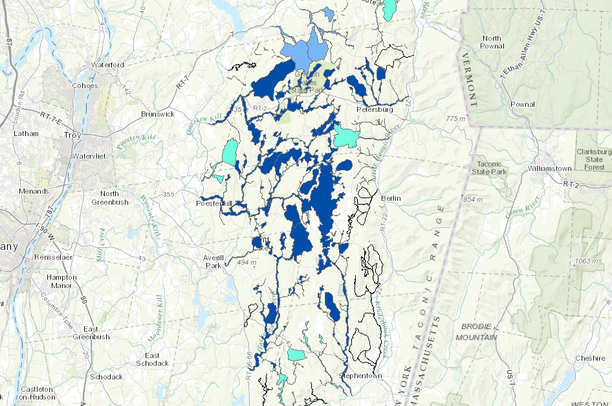
- Aquatic Networks on the Rensselaer Plateau in Rensselaer County, New York
Aquatic Networks on the Rensselaer Plateau in Rensselaer County, New York
May 13, 2014
(Last modified Jun 13, 2015)
Uploaded by
Rensselaer Plateau Alliance
Dataset was reviewed in another manner
- Description:
- Comprehensive map of regionally-important aquatic networks for the Rensselaer Plateau. Aquatic networks represent long, hydrologically-connected two-dimensional landscape-level areas with a centralized stream system plus closely associated buffer areas that most strongly influence the ecology of that system.
- Data Provided By:
-
Rensselaer Plateau Alliance. Conceptualization by the Rensselaer Plateau Ecological Features Working Group (David M. Hunt, Ecological Intuition & Medicine, with assistance from and review by Nick Conrad, Rensselaer Land Trust and New York Natural Heritage Program). Delineation & Digitization: David M. Hunt,
Ecological Intuition & Medicine.
Attribute Population: David M. Hunt, Ecological Intuition & Medicine.
Funding provided by the New York State Department of Environmental Conservation Hudson River Estuary Program and the Rensselaer Plateau Alliance.
- Content date:
- Based primarily on 2004 aerial photograph. Likely to have an accuracy of 95% or more for several decades (past to future), generally averaging an estimate of about 100 years past and future, especially around its centrum stream system. A long to mid-term ecological feature sometimes with portions altered by individual land use (e.g., forest clearing, stream impoundment), both in terms of the network importance and the fine-scale network boundaries. See the Rensselaer Plateau Ecology Report, Aquatic Network Section AN7-8 for more details.
- Citation:
- Hunt, David M. 2013. Important Aquatic Network Map for the Rensselaer Plateau (2004). Averill Park, NY: Rensselaer Plateau Alliance. [GIS database]. http://databasin.org/datasets/f450e3f5dd064895a05072857cdcab2e.
- Spatial Resolution:
- 1:8,000
- Contact Organization:
- Rensselaer Plateau Alliance (RPA). For technical information, contact: Sarah Parks and Rachel Riemann; For content questions, contact David Hunt (518-279-4124).
- Contact Person(s):
- Use Constraints:
 This work is licensed under a Creative Commons Attribution 3.0 License.
- Layer:
- Layer Type:
- Currently Visible Layer:
- All Layer Options:
- Layers in this dataset are based on combinations of the following options. You may choose from these options to select a specific layer on the map page.
- Description:
- Spatial Resolution:
- Credits:
- Citation:
- Purpose:
- Methods:
- References:
- Other Information:
- Time Period:
- Layer Accuracy:
- Attribute Accuracy:
FGDC Standard Metadata XML
Click here to see the full FGDC XML file that was created in Data Basin for this layer.
Original Metadata XML
Click here to see the full XML file that was originally uploaded with this layer.
This dataset is visible to everyone
- Dataset Type:
-
Layer Package
Downloaded by
6 Members
Included in
1 Public Gallery
About the Uploader
Rensselaer Plateau Alliance
Environmental Non-Profit
The Rensselaer Plateau Alliance (RPA), established in 2008, is a diverse group of organizations and people who want to conserve and protect the forested character of the Rensselaer Plateau and the many economic and environmental benefits it provides. A grassroots organization, the RPA is people...