- Data Basin |
- Use Cases |
- Continent-Scale Landscape Conservation Design for Temperate Grasslands of the Great Plains and Chihuahuan Desert
Continent-Scale Landscape Conservation Design for Temperate Grasslands of the Great Plains and Chihuahuan Desert

Explore related items…
Landscape Design for Grassland Conservation Decision Support
Regular assessments of achievements and prioritization mechanisms are required to ensure the efficiency and effectiveness of conservation investments in the context of rapidly changing environmental, social and economic conditions.
In 2013 the North American Intergovernmental Committee on Cooperation for Wilderness and Protected Areas Conservation (NAWPA Committee) agreed to examine the adequacy of the North American conservation estate, considering key attributes of ecological representation, connectivity and resilience. Working with temperate grasslands as a pilot area, analyses concentrated on twelve major grassland ecosystem types that occur across the Great Plains and Chihuahuan Desert regions.
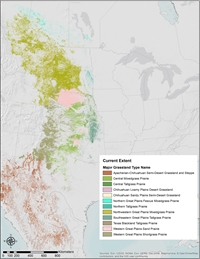
The analyses considered the distribution and historic trend in coverage for each grassland type, identification of key at-risk species associated with grassland types, and the layout and coverage of protected areas within the current and historic distribution of each grassland type.

Spatially explicit analyses then led to the identification of priority Grassland Potential Conservation Areas (GPCAs) that would complement existing conserved areas to enable a maximal representation the grassland diversity into a connected and resilient network. These areas could become a focus for conservation actions to secure or restore grassland habitat, through various mechanisms and programs (e.g., stewardship incentives, tax credit, protected area establishment) by NAWPA participating agencies and other conservation interests.
NatureServe has completed a series of analyses and products in support of NAWPA agency discussions throughout 2015-2017. These included:
- Expert review and refinement of grassland type descriptions and maps.
- Documented historical trends of loss of the 12 major grassland types of the Great Plains.
- Associated species of concern with each of the 12 temperate grassland types.
- Documented resiliency of grassland distributions that considered grassland patch size, current landscape intactness, and core areas.
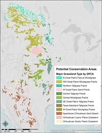
The project then aimed to advance the Convention on Biodiversity 2020 target number 11 of representing the diversity of these grassland types in Grassland Potential Conservation Areas (GPCAs). These areas could provide one important focus for conservation actions to secure or restore grassland habitat. NatureServe ecologists deployed systematic, science-based methods, tools, and data to identify efficient configurations for augmenting the current grassland conservation estate. Grasslands distributions, current managed areas, already proposed conservation areas, landscape resiliency measures, and available distributions for species of concern(e.g., Lesser Prairie Chicken, Greater Sage Grouse, Natural Heritage occurrences, etc.) were used to draft GPCAs using a hexagonal grid (100km2 each)
The analysis resulted in the identification of 177 GPCAs. NatureServe coordinated expert review and refinement by specialists from NatureServe network programs (MT, NE, KS, TX, NM, Chihuahua) and from specialists identified by NAWPA agencies.
In order to support development of conservation strategies, other conservation priorities associated with each GPCA were documented, including current conservation investments and other prioritization efforts, such as sites identified by The Nature Conservancy and Nature Conservancy of Canada ecoregional plans. Current landscape stressors associated with each GPCA were also documented.

This website is intended to provide ready public access to materials generated through this effort. A presentation on this effort is found here: https://youtu.be/McVhFeVy-hs
- Citation
- Patrick Comer. 2017. Continent-Scale Landscape Conservation Design for Temperate Grasslands of the Great Plains and Chihuahuan Desert. In: Data Basin. [First published in Data Basin on Aug 17, 2017; Last Modified on Feb 22, 2019; Retrieved on Jul 20, 2026] <https://databasin.org/articles/bfb06dd10a6a4c1da3e89653562b182e/>
About the Author
Contact: pat_comer@natureserve.orgSince 1985 I have worked in biodiversity conservation and natural resource management. My training was in Forest and Landscape Ecology (Univ. Mich, Ann Arbor). I lived and worked in Costa Rica (1988-1990), Michigan and the Great Lakes region (1991-1997), western...