- Data Basin |
- Datasets |
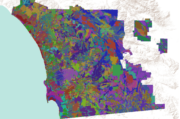
- Soil Survey Geographic (SSURGO) database for San Diego County, California, USA
Soil Survey Geographic (SSURGO) database for San Diego County, California, USA
Feb 22, 2011
(Last modified May 14, 2011)
Uploaded by
Conservation Biology Institute
- Description:
- This data set is a digital soil survey and generally is the most detailed level of soil geographic data developed by the National Cooperative Soil Survey. The information was prepared by digitizing maps, by compiling information onto a planimetric correct base and digitizing, or by revising digitized maps using remotely sensed and other information.
This data set consists of georeferenced digital map data and computerized attribute data. The map data are in a soil survey area extent format and include a detailed, field verified inventory
of soils and miscellaneous areas that normally occur in a repeatable pattern on the landscape and that can be cartographically shown at the scale mapped. A special soil features layer (point and line features) is optional. This layer displays the location of features too small to delineate at the mapping scale, but they are large enough and contrasting enough to significantly influence use and management. The soil map units are linked to attributes in the National Soil Information System relational database, which gives the proportionate extent of the component soils and their properties.
- Data Provided By:
-
U.S. Department of Agriculture, Natural Resources Conservation Service
- Content date:
- not specified
- Spatial Resolution:
- 1:20,000
- Contact Organization:
- USDA NRCS
- Contact Person(s):
- not specified
- Use Constraints:
 This work is licensed under a Creative Commons Attribution 3.0 License.
- Layer:
- Layer Type:
- Currently Visible Layer:
- All Layer Options:
- Layers in this dataset are based on combinations of the following options. You may choose from these options to select a specific layer on the map page.
- Description:
- Spatial Resolution:
- Credits:
- Citation:
- Purpose:
- Methods:
- References:
- Other Information:
- Time Period:
- Layer Accuracy:
- Attribute Accuracy:
FGDC Standard Metadata XML
Click here to see the full FGDC XML file that was created in Data Basin for this layer.
Original Metadata XML
Click here to see the full XML file that was originally uploaded with this layer.
This dataset is visible to everyone
- Dataset Type:
-
Layer Package
Downloaded by
81 Members
Bookmarked by
11 Members
,
3 Groups
Included in
13 Public Maps
,
34 Private Maps
Included in
1 Public Gallery
About the Uploader
Conservation Biology Institute
We provide advanced conservation science, technology, and planning to empower our partners in solving the world’s critical ecological challenges