- Data Basin |
- Datasets |
- Canada Land Inventory - Land Capability for Forestry, Nova Scotia
Canada Land Inventory - Land Capability for Forestry, Nova Scotia
Jul 8, 2010
Uploaded by
Conservation Biology Institute
- Description:
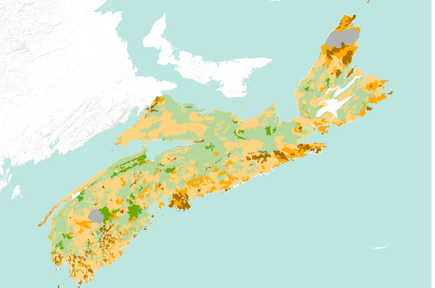
- The mapping of land capability for forestry is based on a national classification system comparable with the other Canada Land Inventory sectors. Land is rated according to seven classes on its capability to grow commercial timber in areas stocked with the optimum number and species of trees. This rating considers the land in its natural state, without improvements such as fertilization, drainage, or amelioration practices. This dataset contains Land Capability Ratings for the surveyed portions of the province of Nova Scotia.
Land ratings and classes may change, however, significant changes will only be achieved through costly and continuing practices. The best lands for tree growth are Class 1 while Class 7 land can not yield timber in commercial quantities, these represent the extremes. Sub-class attributes explain the specific limitations of the area, using a series of codes. Explanation of these codes is found at: http://geogratis.cgdi.gc.ca/cgi-bin/geogratis/cli/forestry.pl
The capability mappings have a scale of 1:250,000 and are accomplished through interpretation of air photographs and field surveys.
- Data Provided By:
- Government of Canada,National Archives of Canada,Visual and Sound Archives Division
- Content date:
- 1966,1985
- Citation:
-
Title: Canada Land Inventory - Land Capability for Forestry, Nova Scotia
Credits: Government of Canada,National Archives of Canada,Visual and Sound Archives Division
Publication Date: 1985
Publisher: Government of Canada, National Archives of Canada, Visual and Sound Archives Division
- Contact Organization:
- Visual and Sound Archives Division, Naitonal Archives of Canada
- Contact Person(s):
- Use Constraints:
- This information is in the public domain.
- Layer:
- Layer Type:
- Currently Visible Layer:
- All Layer Options:
- Layers in this dataset are based on combinations of the following options. You may choose from these options to select a specific layer on the map page.
- Description:
- Spatial Resolution:
- Credits:
- Citation:
- Purpose:
- Methods:
- References:
- Other Information:
- Time Period:
- Layer Accuracy:
- Attribute Accuracy:
FGDC Standard Metadata XML
Click here to see the full FGDC XML file that was created in Data Basin for this layer.
Original Metadata XML
Click here to see the full XML file that was originally uploaded with this layer.
This dataset is visible to everyone
- Dataset Type:
-
Layer Package
Downloaded by
2 Members
Included in
3 Private Maps
About the Uploader
Conservation Biology Institute
We provide advanced conservation science, technology, and planning to empower our partners in solving the world’s critical ecological challenges