- Data Basin |
- Datasets |
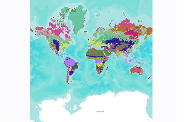
- SYNMAP Global Potential Vegetation
SYNMAP Global Potential Vegetation
Oct 19, 2011
(Last modified Oct 18, 2014)
Uploaded by
Conservation Biology Institute
- Description:
- SYNMAP is a new joint I-km global land cover product with improved characteristics for land cover parameterization of the carbon cycle models that reduces land cover uncertainties in carbon budget calculations. The overall advantage of the SYNMAP legend is that all classes are properly defined in terms of plant functional type mixtures, which can be remotely sensed and include the definitions of leaf type and longevity for each class with a tree component. SYNMAP is currently used for parameterization in a European model intercomparison initiative of three global vegetation models: BIOME-BGC, LPJ, and ORCHIDEE. Corroboration of SYNMAP against GLCC, GLC2000 and MODIS land cover products reveals improved agreement of SYNMAP with all other land cover products and therefore indicates the successful exploration of synergies between the different products. However, given that we cannot provide extensive validation using reference data we are unable to prove that SYNMAP is actually more accurate.
- Data Provided By:
- Jung, M, Henkel, K, Herold, M, Churkina, G
- Content date:
- not specified
- Citation:
- Jung, M, Henkel, K, Herold, M, Churkina, G (2006). Exploiting synergies of global land cover products for carbon cycle modeling. REMOTE SENSING OF ENVIRONMENT, 101(4), 534-553.
- Spatial Resolution:
- 1 km x 1 km
- Contact Organization:
- not specified
- Contact Person(s):
- Use Constraints:
 This work is licensed under a Creative Commons Attribution 3.0 License.
- Layer:
- Layer Type:
- Currently Visible Layer:
- All Layer Options:
- Layers in this dataset are based on combinations of the following options. You may choose from these options to select a specific layer on the map page.
- Description:
- Spatial Resolution:
- Credits:
- Citation:
- Purpose:
- Methods:
- References:
- Other Information:
- Time Period:
- Layer Accuracy:
- Attribute Accuracy:
FGDC Standard Metadata XML
Click here to see the full FGDC XML file that was created in Data Basin for this layer.
Original Metadata XML
Click here to see the full XML file that was originally uploaded with this layer.
This dataset is visible to everyone
- Dataset Type:
-
NetCDF File
Downloaded by
84 Members
Bookmarked by
2 Members
Included in
2 Public Maps
,
2 Private Maps
Included in
1 Private Gallery
About the Uploader
Conservation Biology Institute
We provide advanced conservation science, technology, and planning to empower our partners in solving the world’s critical ecological challenges