- Data Basin |
- Datasets |
- Wind Power Class
Wind Power Class
May 8, 2014
(Last modified Aug 27, 2017)
Uploaded by
Northeast
This map service is unavailable
- Description:
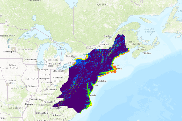
- This dataset provides an estimate of annual wind resources for the Northeast. It was developed by the National Renewable Energy Laboratory of the U.S. Department of Energy. The wind power classes are described in the attached table.
Areas designated class 3 or greater are suitable for most utility-scale wind turbine applications, whereas class 2 areas are marginal for utility-scale applications but may be suitable for rural applications. Class 1 areas are generally not suitable, although a few locations (e.g. exposed hilltops not shown on the maps) with adequate wind resource for wind turbine applications may exist in some class 1 areas. The degree of certainty with which the wind power class can be specified depends on three factors: the abundance and quality of wind data; the complexity of terrain; and the geographical variability of the resource. A certainty rating was assigned to each grid cell based on these three factors, and is included in the Wind Energy Resource Atlas of the United States.
Wind Power Class Resource Potentials: 1= Poor, 2=Marginal, 3=Fair, 4=Good, 5=Excellent, 6=Outstanding, 7=Superb
- Data Provided By:
- National Renewable Energy Laboratory of the U.S. Department of Energy.
- Data Hosted by:
- ScienceBase (USGS) View Record
- Map Service URL:
- https://www.sciencebase.gov/arcgis/rest/services/Catalog/535a66cde4b0d0864496276b/MapServer/
- Content date:
- 2013 (Acquisition)
- Contact Organization:
- National Renewable Energy Laboratory of the U.S. Department of Energy
- Contact Person(s):
- not specified
- Use Constraints:
 This work is licensed under a Creative Commons Attribution 3.0 License.
- Layer:
- Layer Type:
- Currently Visible Layer:
- All Layer Options:
- Layers in this dataset are based on combinations of the following options. You may choose from these options to select a specific layer on the map page.
- Description:
- Spatial Resolution:
- Credits:
- Citation:
- Purpose:
- Methods:
- References:
- Other Information:
- Time Period:
- Layer Accuracy:
- Attribute Accuracy:
FGDC Standard Metadata XML
Click here to see the full FGDC XML file that was created in Data Basin for this layer.
Original Metadata XML
Click here to see the full XML file that was originally uploaded with this layer.
This dataset is visible to everyone
- Dataset Type:
-
External Map Service (ArcGIS)
Bookmarked by
3 Members
Included in
1 Public Gallery
[{"url": "https://www.sciencebase.gov/catalog/file/get/535a66cde4b0d0864496276b", "title": "Download All Attached Files from ScienceBase"}, {"url": "https://www.sciencebase.gov/catalog/file/get/535a66cde4b0d0864496276b?f=__disk__ba%2Fd5%2F5d%2Fbad55d444b543d6d31e13135a1ac614f99c8680e", "title": "Download Original Metadata"}, {"url": "https://www.sciencebase.gov/catalog/file/get/535a66cde4b0d0864496276b?f=__disk__0d%2Fca%2Fc5%2F0dcac5cac13f67c98736e3de1d37b8004585edbf", "title": "Table, classes of wind power density.docx"}, {"url": "http://d25ripjvlq5c77.cloudfront.net/Wind.zip", "title": "DOWNLOAD ORIGINAL DATA HERE"}]
About the Uploader
Northeast
with Science Applications, Northeast
Administration account for the Northeast Conservation Planning Atlas.