- Data Basin |
- Datasets |
- Electric Substations, California
Electric Substations, California
- Description:
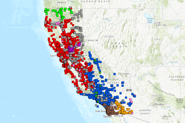
The Electric Substation geospatial data layer contains point features representing transmission substations and some distribution substations in California.
These substations are fed by electric transmission lines and are used to step-up and step-down the voltage of electricity being carried by the lines, or simply to connect together various lines and maintain reliability of supply. These substations can be located on the surface within fenced enclosures, within special purpose buildings, on rooftops (in urban environments), or underground. A substation feature is also used to represent a location where one transmission line "taps" into another.
The transmission line, substation and power plant mapping database were started in 1990 by the CEC GIS staff. The final project was completed in October 2010. The enterprise GIS system on CEC's critical infrastructure database was lead by GIS Unit in November 2014 and was implemented in May 2016.
The data was derived from utility companies and USGS topographic map, Some of the data was rectified from GE and Platts substation geospatial data. The sources for the substation point digitizing are including sub-meter resolution of Digital Globe, Bing, Google, ESRI and NAIP aerial imageries, with scale at least 1:10,000. Occasionally, USGS Topographic map, Google Street View and Bing Bird's Eye are used to verify the precise location of a facility.
- Data Provided By:
-
California Energy Commission GIS Unit;REAT, Caliso, PG&E;, SCE, SDG&E;, LADWP, WAPA, IID, SMUD, MID, MWD, GE, Platts, ANZA Electric Cooperative, Bear Valley, City of Anaheim PUD, City of Colton, City of Vernon, Plumas Sierram PUC, Riverside Public Utilities, and Silicon Valley Power.
- Content date:
- 1/4/2018
- Contact Organization:
- The California Energy Commission (CEC)
- Contact Person(s):
- Use Constraints:
- DISCLAIMER : The California Energy Commission makes no warranties, whether expressed or implied, as to the suitability or accuracy of the product for any particular purpose. Any use of this information is at the user's own risk. For further information or suggestions concerning maps/data, please contact: California Energy Commission- Energy Facilities Siting Division – Cartography Unit, 1516 9th Street, MS48, Sacramento, CA 95814. For any further questions, please call Terry Rose or Fui Thong or Travis David at (916) 654-3902.
- Layer:
- Layer Type:
- Currently Visible Layer:
- All Layer Options:
- Layers in this dataset are based on combinations of the following options. You may choose from these options to select a specific layer on the map page.
- Description:
- Spatial Resolution:
- Credits:
- Citation:
- Purpose:
- Methods:
- References:
- Other Information:
- Time Period:
- Layer Accuracy:
- Attribute Accuracy:
- Dataset Type:
-
Layer Package
About the Uploader
We provide advanced conservation science, technology, and planning to empower our partners in solving the world’s critical ecological challenges