- Data Basin |
- Datasets |
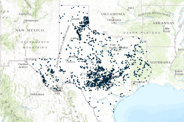
- Springs of Texas
Springs of Texas
Apr 7, 2014
Uploaded by
Gulf Coast Prairie LCC
Dataset was scientifically peer reviewed
- Description:
- Springs are naturally occurring features that convey excess ground water to the land surface; they represent a transition from ground water to surface water. Water issues through one opening, multiple openings, or numerous seeps in the rock or soil. This dataset provides information about springs in Texas including spring names, identification numbers, location, and, if available, water source and use. This dataset does not include every spring in Texas, but is limited to an aggregation of selected digital and hard-copy data of the Texas Water Development Board, the U.S. Geological Survey, and Capitol Environmental Services.
- Data Provided By:
- This dataset was specifically developed to aggregate information about springs and spring flow into a singular digital database, as part of a cooperative effort between the U.S. Geological Survey (USGS) and the Texas Water Development Board (TWDB). Capitol Environmental Services also contributed information about springs and spring flow. The Texas Parks and Wildlife Department (TPWD) provided additional support for the release of Version 1.2.
- Content date:
- not specified
- Contact Organization:
- U.S. Geological Survey
- Contact Person(s):
- not specified
- Use Constraints:
 This work is licensed under a Creative Commons Attribution 3.0 License.
- Layer:
- Layer Type:
- Currently Visible Layer:
- All Layer Options:
- Layers in this dataset are based on combinations of the following options. You may choose from these options to select a specific layer on the map page.
- Description:
- Spatial Resolution:
- Credits:
- Citation:
- Purpose:
- Methods:
- References:
- Other Information:
- Time Period:
- Layer Accuracy:
- Attribute Accuracy:
FGDC Standard Metadata XML
Click here to see the full FGDC XML file that was created in Data Basin for this layer.
Original Metadata XML
Click here to see the full XML file that was originally uploaded with this layer.
This dataset is visible to everyone
- Dataset Type:
-
Layer Package
Downloaded by
129 Members
Bookmarked by
7 Members
,
2 Groups
Included in
4 Public Maps
,
4 Private Maps
Included in
4 Public Galleries
About the Uploader
Gulf Coast Prairie LCC
with Gulf Coast Prairie Landscape Conservation Cooperative
This is the admin account for the Gulf Coast Prairie LCC Conservation Planning Atlas