- Data Basin |
- Datasets |
- Extant Vernal Pool Distribution: California's Great Valley, 2012 [ds1070]
Extant Vernal Pool Distribution: California's Great Valley, 2012 [ds1070]
Jul 27, 2015
Uploaded by
Dustin Pearce
- Description:
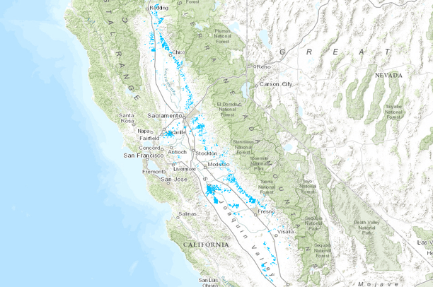
- This mapping documents the changes in extent and condition of vernal pool habitat in the Great Valley between 2005 and 2012. "Vernal pool habitat" is defined as vernal pools and the surrounding upland (typically grassland) habitat matrix. The 2005 basemap was created by using double-blind mapping protocol and included 21.4 million acres in and surrounding the Sacramento and San Joaquin valleys (Witham et al 2013). The area included in the 2012 remapping effort focused on the 807,820 acres identified in the 2005 map and areas immediately surrounding the previously mapped polygons. Special attention was paid to areas where habitat was being created through mitigation banking. The result of the 2012 remapping shows 764,868 acres of extant habitat. This is down from 2005, a net reduction of 42,952 acres. Habitat actually was eliminated from 47,306 acres, but these losses were partially off-set by 1,679 acres of mitigation banks built since 2005, and by 2,675 acres that we missed in the 2005 mapping. In the seven years since the Recovery Plan was adopted, some 6,758 acres per year on average have been lost. THIS CONTAINS ONLY THE EXTANT POLYGONS AS OF 2012.
- Data Provided By:
- Carol W. Witham, Robert F. Holland, John Vollmar
- Content date:
- 2012
- Contact Organization:
- not specified
- Contact Person(s):
- Use Constraints:
- Credit authors
- Layer:
- Layer Type:
- Currently Visible Layer:
- All Layer Options:
- Layers in this dataset are based on combinations of the following options. You may choose from these options to select a specific layer on the map page.
- Description:
- Spatial Resolution:
- Credits:
- Citation:
- Purpose:
- Methods:
- References:
- Other Information:
- Time Period:
- Layer Accuracy:
- Attribute Accuracy:
FGDC Standard Metadata XML
Click here to see the full FGDC XML file that was created in Data Basin for this layer.
Original Metadata XML
Click here to see the full XML file that was originally uploaded with this layer.
This dataset is visible to everyone
- Dataset Type:
-
Layer Package
Downloaded by
18 Members
Bookmarked by
1 Group
About the Uploader
Dustin Pearce
GIS Analyst with Conservation Biology Institute
Dustin Pearce is GIS Analyst with the Conservation Biology Institute. He has focused geospatial and stakeholder engagement experience in the San Joaquin Valley of California on agricultural lands, natural lands, and renewable energy development. His experience and background allows him to work with...