- Data Basin |
- Datasets |
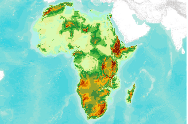
- 30 arc-second DEM of Africa
30 arc-second DEM of Africa
Jul 29, 2010
(Last modified Aug 2, 2010)
Uploaded by
Conservation Biology Institute
Recommended by Tara Starr Marvin
- Description:
- GTOPO30 is a global digital elevation model (DEM) resulting from a collaborative effort led by the staff at the U.S. Geological Survey's EROS Data Center in Sioux Falls, South Dakota. The name GTOPO30 is derived from the fact that elevations in GTOPO30 are regularly spaced at 30-arc seconds (approximately 1 kilometer). GTOPO30 was developed to meet the needs of the geospatial data user community for regional and continental scale topographic data. This release represents the completion of global coverage of 30-arc second elevation data that have been available from the EROS Data Center beginning in 1993. Several areas have been updated and the entire global data set has been repackaged, so these data supersede the previously released continental data sets.
- Data Provided By:
- U.S. Geological Survey's Center for Earth Resources Observation and Science (EROS)
- Content date:
- 1996
- Citation:
-
Title: 30 arc-second DEM of Africa
Credits: U.S. Geological Survey's Center for Earth Resources Observation and Science (EROS)
Publication Date: 1996
Other Citation Info: National Aeronautics and Space Administration (NASA), the United Nations Environment Programme/Global Resource Information Database (UNEP/GRID), the U.S. Agency for International Development (USAID), the Instituto Nacional de Estadistica Geografica e Informatica (INEGI) of Mexico, the Geographical Survey Institute (GSI) of Japan, Manaaki Whenua Landcare Research of New Zealand, and the Scientific Committee on Antarctic Research (SCAR).
Larger Works:
- Contact Person(s):
- Use Constraints:
 This work is licensed under a Creative Commons Attribution-NonCommercial 3.0 License.
- Layer:
- Layer Type:
- Currently Visible Layer:
- All Layer Options:
- Layers in this dataset are based on combinations of the following options. You may choose from these options to select a specific layer on the map page.
- Description:
- Spatial Resolution:
- Credits:
- Citation:
- Purpose:
- Methods:
- References:
- Other Information:
- Time Period:
- Layer Accuracy:
- Attribute Accuracy:
FGDC Standard Metadata XML
Click here to see the full FGDC XML file that was created in Data Basin for this layer.
Original Metadata XML
Click here to see the full XML file that was originally uploaded with this layer.
This dataset is visible to everyone
- Dataset Type:
-
Layer Package
Downloaded by
782 Members
Bookmarked by
25 Members
,
2 Groups
Included in
35 Public Maps
,
28 Private Maps
Included in
1 Public Gallery
About the Uploader
Conservation Biology Institute
We provide advanced conservation science, technology, and planning to empower our partners in solving the world’s critical ecological challenges