- Data Basin |
- Datasets |
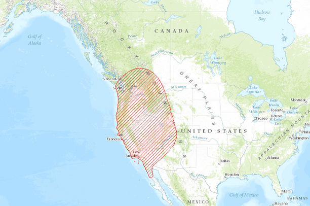
- Historic Range of the California Condor, circa 1800
Historic Range of the California Condor, circa 1800
Jul 17, 2015
Uploaded by
PacificSouthwestRegion
This map service is unavailable
- Description:
The data was developed from Map 1 on page 5 of Introduction to the California Condor by Snyder and Snyder, 2005. The data represents what the authors described as the "approximate range of the California Condor in about 1800". In early historical times, the authors described the California Condor as being widely distributed along the west coast of North America, from present day British Columbia in Canada to the mountains of northern Baja California in Mexico.
- Data Provided By:
- Created by the U.S. Fish & Wildlife Service, based on data in "Introduction to the California Condor" by Snyder and Snyder, 2005.
- Data Hosted by:
- ScienceBase (USGS) View Record
- Map Service URL:
- https://www.sciencebase.gov/arcgis/rest/services/Catalog/55a94ad1e4b0183d66e467e3/MapServer/
- Content date:
- 2005-06-01 (Publication Date)
- Contact Organization:
- U.S. Fish and Wildlife Service
- Contact Person(s):
- not specified
- Use Constraints:
 This work is licensed under a Creative Commons Attribution 3.0 License.
- Layer:
- Layer Type:
- Currently Visible Layer:
- All Layer Options:
- Layers in this dataset are based on combinations of the following options. You may choose from these options to select a specific layer on the map page.
- Description:
- Spatial Resolution:
- Credits:
- Citation:
- Purpose:
- Methods:
- References:
- Other Information:
- Time Period:
- Layer Accuracy:
- Attribute Accuracy:
FGDC Standard Metadata XML
Click here to see the full FGDC XML file that was created in Data Basin for this layer.
Original Metadata XML
Click here to see the full XML file that was originally uploaded with this layer.
This dataset is visible to everyone
- Dataset Type:
-
External Map Service (ArcGIS)
Bookmarked by
1 Member
,
2 Groups
Included in
2 Public Maps
Included in
1 Public Gallery
[{"url": "https://www.sciencebase.gov/catalog/file/get/55a94ad1e4b0183d66e467e3", "title": "Download All Attached Files from ScienceBase"}]
About the Uploader
PacificSouthwestRegion
Multiple Administrators with US Fish and Wildlife Service
This US Fish and Wildlife User Group is responsible for maintaining the Pacific Southwest Region Web Mapping Portal