- Data Basin |
- Datasets |
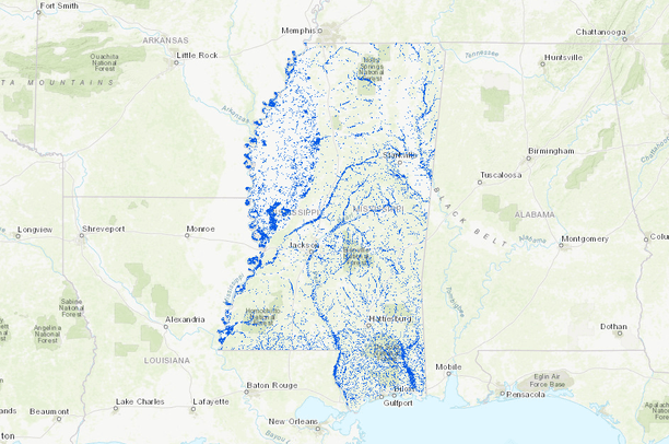
- Mississippi Floodplain Forests (Simplified)
Mississippi Floodplain Forests (Simplified)
Aug 24, 2018
(Last modified Jan 26, 2021)
Uploaded by
Conservation Biology Institute
- Description:
- Mississippi Floodplain Forests extracted from the Landfire 2014 dataset for:
- Southern Coastal Plain Seepage Swamp and Baygall Woodland
- Central Interior and Appalachian Riparian Forest
- Gulf and Atlantic Coastal Plain Floodplain Forest
- Gulf and Atlantic Coastal Plain Small Stream Riparian Woodland
- Gulf and Atlantic Coastal Plain Swamp Systems
- Lower Mississippi River Flatwoods
- Introduced Wetland Vegetation-Tree
- Pinus elliottii Saturated Temperate Woodland Alliance
These areas represent areas of bottomland hardwood forests within Mississippi covering 4.1 million acres within the state. These data were simplified when converted to a polygon and all polygons less than 5 acres removed to remove small areas. Should only be used for large scale evaluation of floodplain forest areas. - Southern Coastal Plain Seepage Swamp and Baygall Woodland
- Data Provided By:
- Landfire - Existing Vegetation Type
- Content date:
- not specified
- Spatial Resolution:
- 30 (Meter)
- Contact Organization:
- not specified
- Contact Person(s):
- Use Constraints:
 This work is licensed under a Creative Commons Attribution 3.0 License.
- Layer:
- Layer Type:
- Currently Visible Layer:
- All Layer Options:
- Layers in this dataset are based on combinations of the following options. You may choose from these options to select a specific layer on the map page.
- Description:
- Spatial Resolution:
- Credits:
- Citation:
- Purpose:
- Methods:
- References:
- Other Information:
- Time Period:
- Layer Accuracy:
- Attribute Accuracy:
FGDC Standard Metadata XML
Click here to see the full FGDC XML file that was created in Data Basin for this layer.
Original Metadata XML
Click here to see the full XML file that was originally uploaded with this layer.
This dataset is visible to everyone
- Dataset Type:
-
Layer Package
Downloaded by
1 Member
Bookmarked by
1 Group
About the Uploader
Conservation Biology Institute
We provide advanced conservation science, technology, and planning to empower our partners in solving the world’s critical ecological challenges