- Data Basin |
- Datasets |
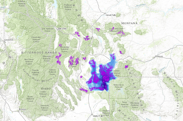
- Grizzly Bear Core Habitat and Corridors, Madison Valley, Montana
Grizzly Bear Core Habitat and Corridors, Madison Valley, Montana
May 6, 2015
Uploaded by
GNLCC Connectivity Atlas Data Coordinator
- Description:
- The Madison Valley is an important wildlife linkage zone between core habitats at the center of the Greater Yellowstone Ecosystem (GYE) and habitats at the western edge of the GYE and beyond. This report identifies lands in the Madison Valley watershed which are significant for conservation based on the common occurrence of key threats to wildlife and their critical habitats and migration corridors. The species emphasized in this report - grizzly bear, wolverine, and pronghorn antelope - were selected for their need to move across or along the valley to maintain traditional migration routes, enable genetic exchange across the valley, or expand into unoccupied habitat. The selected species are also intended to serve as umbrellas for other species with similar connectivity or habitat requirements, meaning that conservation efforts that are focused on these species will also likely benefit other species with similar needs. Connectivity models were derived using GIS, information gleaned from published literature, and expert opinion. The habitat models for grizzly bear and wolverine were used to develop least cost path (LCP) corridor maps to predict areas where animals were most likely to cross the valley from one mountain range to another. Pronghorn migration routes were mapped by Steve Primm using information collected from area land owners and wildlife experts.
- Data Provided By:
- Wildlife Conservation Society, Groves, C., Brock, B., Toivola, A.
- Content date:
- 2005
- Citation:
-
Groves, C., Brock, B., and Toivola, A. 2005. High-Quality Wildlife Connectivity Areas in the Madison Valley Watershed. Wildlife Conservation Society, Greater YellowstoneProgram. Bozeman, MT.
- Contact Organization:
- HoloScene Wildlife Services LLC
- Contact Person(s):
- Use Constraints:
- These data layers are intended only for use in identifying lands in the Madison Valley watershed which are a significant for conservation based on the common occurrence of key threats to wildlife and their critical habitats and migration corridors. The data providers assume no responsibility for uses inconsistent with this intent. Data are available only by request to the data originators.
- Layer:
- Layer Type:
- Currently Visible Layer:
- All Layer Options:
- Layers in this dataset are based on combinations of the following options. You may choose from these options to select a specific layer on the map page.
- Description:
- Spatial Resolution:
- Credits:
- Citation:
- Purpose:
- Methods:
- References:
- Other Information:
- Time Period:
- Layer Accuracy:
- Attribute Accuracy:
FGDC Standard Metadata XML
Click here to see the full FGDC XML file that was created in Data Basin for this layer.
Original Metadata XML
Click here to see the full XML file that was originally uploaded with this layer.
This dataset is visible to everyone
- Dataset Type:
-
Layer Package
Bookmarked by
8 Members
,
2 Groups
Included in
2 Public Maps
,
7 Private Maps
Included in
1 Public Gallery
About the Uploader
GNLCC Connectivity Atlas Data Coordinator
with Great Northern LCC
This is the administrator account for managing the Great Northern LCC Connectivity Atlas.