- Data Basin |
- Datasets |
- Historic Vegetation Base Map (Pre-1900), Central Valley Historic Mapping Project
Historic Vegetation Base Map (Pre-1900), Central Valley Historic Mapping Project
May 15, 2015
(Last modified Jun 13, 2015)
Uploaded by
Conservation Biology Institute
- Description:
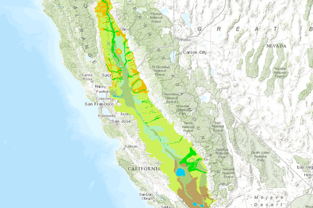
- INTRODUCTION In 2001, the US Fish and Wildlife Service (USFWS) and the U.S. Bureau of Reclamation (BOR) contracted with the California State University, Chico Research Foundation (Department of Geography and Planning and the Geographical Information Center) to develop a set of historic natural vegetation maps for the Great Central Valley of California (GCV). Natural vegetation in the GCV was divided into eight classification types: valley foothill hardwood, chaparral, grassland, riparian, alkali desert scrub, wetlands, aquatic and other floodplain habitat. A geographic information system (GIS) was created to quantify vegetation changes over the last 100 years. Four maps which represented the pre 1900, 1940, 1960, and 1990 eras were produced to identify major changes that have occurred in the GCV due, in part, to hydrologic alterations associated with the Central Valley Project (1945) and the California State Water Project (1968).SUMMARY Development of the map set and GIS consisted of researching libraries for archival information, developing GIS tools for data input, and displaying and analyzing information from a variety of agency and academic sources. Over seven hundred maps were scanned and will ultimately be made available on a library site for viewing and/or downloading. The Pre-1900 Base Map was the most difficult to construct due to the limited information recorded at that time. Vegetation polygons were developed from several independent map sources. The quality of information on the source maps varies by area and by source. Map series were more readily available for the 1945, 1960 and 1990 time periods. The maps are GIS-based and can be used to estimate vegetation change over time. In all cases attempts were made to gather the best information available and to create a bank of accessible information that can be utilized in future research efforts. We see this project as a good base for continued additions and refinements rather than as an end product. We would like to invite other interested federal and state agencies to participate in the project.
- Data Provided By:
-
California State University, Chico Department of Geography and Planning and Geographic Information Centerhttp://www.waterboards.ca.gov/waterrights/water_issues/programs/bay_delta/docs/cmnt081712/sldmwa/csuchicodptofgeographyandplanningcentralvalley.pdfData downloaded from: http://sjvgreenprint.ice.ucdavis.edu/content/data-list
- Content date:
- pre-1900
- Citation:
- THE CENTRAL VALLEY HISTORIC MAPPING PROJECT, 2003. California State University, Chico Department of Geography and Planning and Geographic Information Center
- Contact Organization:
- not specified
- Contact Person(s):
- not specified
- Use Constraints:
 This work is licensed under a Creative Commons Attribution 3.0 License.
- Layer:
- Layer Type:
- Currently Visible Layer:
- All Layer Options:
- Layers in this dataset are based on combinations of the following options. You may choose from these options to select a specific layer on the map page.
- Description:
- Spatial Resolution:
- Credits:
- Citation:
- Purpose:
- Methods:
- References:
- Other Information:
- Time Period:
- Layer Accuracy:
- Attribute Accuracy:
FGDC Standard Metadata XML
Click here to see the full FGDC XML file that was created in Data Basin for this layer.
Original Metadata XML
Click here to see the full XML file that was originally uploaded with this layer.
This dataset is visible to everyone
- Dataset Type:
-
Layer Package
Downloaded by
102 Members
Bookmarked by
3 Members
,
2 Groups
Included in
2 Public Maps
,
4 Private Maps
Included in
5 Public Galleries
About the Uploader
Conservation Biology Institute
We provide advanced conservation science, technology, and planning to empower our partners in solving the world’s critical ecological challenges