- Data Basin |
- Datasets |
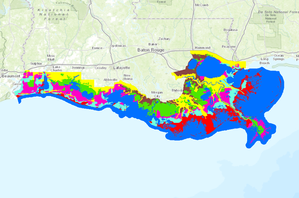
- 2007 Louisiana Coastal Marsh-Vegetative Type Map
2007 Louisiana Coastal Marsh-Vegetative Type Map
Nov 21, 2013
Uploaded by
Gulf Coast Prairie LCC
Recommended by Tara Starr Marvin
- Description:
- This data set contains vector line information. The original data set was collected through visual field observation by Charles Sasser and Jennke Visser of LSU. The observations were made while flying over the study area (Louisiana Coastal Zone) in a Bell 206 Jet Ranger helicopter. Flight was along north/south transects spaced 1.87 miles apart from the Texas State line to the Mississippi State line. Vegetative data was obtained at pre-determined stations spaced at 0.5 miles along each transect. The stations were located using a Trimble Ag 122 Global Positioning System (GPS) and a computer running ArcGIS. This information was recorded manually into field tally sheets and later this information was entered into a Microsoft Access database. At this point, this information was brought into a GIS application by converting the file to a database format (dbf). The marsh type delineation lines were produced by freehanding contours through on-screen interpretation. The flight line data was used as a guide for drawing the lines. The new data set resulted in a line coverage delineating vegetative marsh types. Coverage is of the coastal region of the State of Louisiana.
- Data Provided By:
- Louisiana Department of Wildlife and Fisheries, Fur and Refuge Division, LSU AgCenter, and U.S. Geological Survey's National Wetlands Research Center
- Content date:
- 20070601, 20071012
- Contact Organization:
- USGS BRD's National Wetlands Research Center
- Contact Person(s):
- Use Constraints:
- Acknowledgment of the NWRC as a data source would be appreciated in products developed from this data, and such acknowledgment as is standard for citation and legal practices for data source is expected by users of this data. Sharing new data layers developed directly from this data would also be appreciated by NWRC staff. Users should be aware that comparisons with other data sets for the same area from other time periods might be inaccurate due to inconsistencies resulting from changes in photo interpretation, mapping conventions, and digital processes over time. This data is not a legal document and is not to be used as such. This data is not certified.
- Layer:
- Layer Type:
- Currently Visible Layer:
- All Layer Options:
- Layers in this dataset are based on combinations of the following options. You may choose from these options to select a specific layer on the map page.
- Description:
- Spatial Resolution:
- Credits:
- Citation:
- Purpose:
- Methods:
- References:
- Other Information:
- Time Period:
- Layer Accuracy:
- Attribute Accuracy:
FGDC Standard Metadata XML
Click here to see the full FGDC XML file that was created in Data Basin for this layer.
Original Metadata XML
Click here to see the full XML file that was originally uploaded with this layer.
This dataset is visible to everyone
- Dataset Type:
-
Layer Package
Downloaded by
36 Members
Bookmarked by
1 Group
Included in
4 Private Maps
Included in
5 Public Galleries
About the Uploader
Gulf Coast Prairie LCC
with Gulf Coast Prairie Landscape Conservation Cooperative
This is the admin account for the Gulf Coast Prairie LCC Conservation Planning Atlas