- Data Basin |
- Datasets |
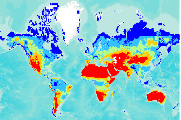
- Global Annual Average Climate Moisture Index (CMI)
Global Annual Average Climate Moisture Index (CMI)
Jul 1, 2010
Uploaded by
Conservation Biology Institute
- Description:
- This dataset depicts annual average climate moisture index (CMI, Willmott and Feddema, 1992) computed using the ratio of annual precipitation (P) to annual potential evapotranspiration, (PET).al., 2004. Climate Moisture Index (CMI) indicator for the globe on a 0.5 X 0.5 degree global grid. The CMI illustrates the relationship between plant water demand and available precipitation. The CMI indicator ranges from -1 to +1, with wet climates showing positive CMI, and dry climates negative CMI.
Climate Moisture Index (CMI) = (P / PET) -1 when P < PET OR
Climate Moisture Index (CMI) = 1- (PET / P) when P = PET
P = long term annual precipitation (mm/yr) computed from Mitchell et al. (2003) PET = potential evapotranspiration (mm/yr) estimated using the physically-based function of Shuttleworth and Wallace (1985).
- Data Provided By:
- Vorosmarty,C. J.,Water Systems Analysis Group,University of New Hampshire, NH
- Content date:
- not specified
- Citation:
-
Title: Global Annual Average Climate Moisture Index (CMI)
Credits: Vorosmarty,C. J.,Water Systems Analysis Group,University of New Hampshire, NH
Publication Date: 2005
Other Citation Info: Vorosmarty, C. J., E. M. Douglas, P.A. Green and C. Revenga (2005), Geospatial indicators of emerging water stress: An application to Africa, Ambio, 34(3), 230 - 236. Prof. Geographer 44: 84-87.
- Contact Organization:
- Water Systems Analysis Group, Complex System Research Center, Institute for the Study of Earth, Oceans and Space, University of New Hampshire, USA
- Contact Person(s):
- Use Constraints:
- Reference Vorosmarty et. al., 2005
- Layer:
- Layer Type:
- Currently Visible Layer:
- All Layer Options:
- Layers in this dataset are based on combinations of the following options. You may choose from these options to select a specific layer on the map page.
- Description:
- Spatial Resolution:
- Credits:
- Citation:
- Purpose:
- Methods:
- References:
- Other Information:
- Time Period:
- Layer Accuracy:
- Attribute Accuracy:
FGDC Standard Metadata XML
Click here to see the full FGDC XML file that was created in Data Basin for this layer.
Original Metadata XML
Click here to see the full XML file that was originally uploaded with this layer.
This dataset is visible to everyone
- Dataset Type:
-
Layer Package
Downloaded by
63 Members
Bookmarked by
3 Members
,
1 Group
Included in
4 Public Maps
,
4 Private Maps
About the Uploader
Conservation Biology Institute
We provide advanced conservation science, technology, and planning to empower our partners in solving the world’s critical ecological challenges