- Data Basin |
- Datasets |
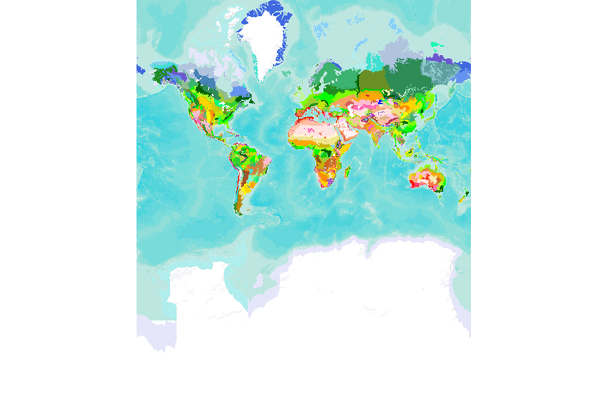
- Terrestrial Ecoregions of the World
Terrestrial Ecoregions of the World
Oct 27, 2010
(Last modified May 8, 2023)
Uploaded by
Conservation Biology Institute
Dataset was scientifically peer reviewed
- Description:
- This map depicts the 825 terrestrial ecoregions of the globe. Ecoregions are relatively large units of land containing distinct assemblages of natural communities and species, with boundaries that approximate the original extent of natural communities prior to major land-use change. This comprehensive, global map provides a useful framework for conducting biogeographical or macroecological research, for identifying areas of outstanding biodiversity and conservation priority, for assessing the representation and gaps in conservation efforts worldwide, and for communicating the global distribution of natural communities on earth. We have based ecoregion delineations on hundreds of previous biogeographical studies, and refined and synthesized existing information in regional workshops over 10 years to assemble the global dataset. Ecoregions are nested within two higher-order classifications: biomes (14) and biogeographic realms (8). Together, these nested classification levels provide a framework for comparison among units and the identification of representative habitats and species assemblages. Ecoregions have increasingly been adopted by research scientists, conservation organizations, and donors as a framework for analyzing biodiversity patterns, assessing conservation priorities, and directing effort and support (Ricketts et al. 1999a; Wikramanayake et al. 2001; Ricketts et al. 1999b; Olson & Dinerstein 1998; Groves et al. 2000; Rosenzweig et al. 2003; and Luck et al. 2003). More on the approach to ecoregion mapping, the logic and design of the framework, and previous and potential uses are discusses in Olson et al. (2001) and Ricketts et al. (1999a).Biome codes and their descriptions are described below:Value: 1
Definition: Tropical & Subtropical Moist Broadleaf Forests
Value: 2
Definition: Tropical & Subtropical Dry Broadleaf Forests
Value: 3
Definition: Tropical & Subtropical Coniferous Forests
Value: 4
Definition: Temperate Broadleaf & Mixed Forests
Value: 5
Definition: Temperate Conifer Forests
Value: 6
Definition: Boreal Forests/Taiga
Value: 7
Definition: Tropical & Subtropical Grasslands, Savannas & ShrublandsValue: 8
Definition: Temperate Grasslands, Savannas & Shrublands
Value: 9
Definition: Flooded Grasslands & Savannas
Value: 10
Definition: Montane Grasslands & Shrublands
Value: 11
Definition: TundraValue: 12
Definition: Mediterranean Forests, Woodlands & Scrub
Value: 13
Definition: Deserts & Xeric Shrublands
Value: 14
Definition: Mangroves
- Data Provided By:
- World Wildlife Fund - USA
- Content date:
- not specified
- Contact Organization:
- Conservation Science Program - World Wildlife Fund
- Contact Person(s):
- Use Constraints:
 This work is licensed under a Creative Commons Attribution-NonCommercial 3.0 License.
- Layer:
- Layer Type:
- Currently Visible Layer:
- All Layer Options:
- Layers in this dataset are based on combinations of the following options. You may choose from these options to select a specific layer on the map page.
- Description:
- Spatial Resolution:
- Credits:
- Citation:
- Purpose:
- Methods:
- References:
- Other Information:
- Time Period:
- Layer Accuracy:
- Attribute Accuracy:
FGDC Standard Metadata XML
Click here to see the full FGDC XML file that was created in Data Basin for this layer.
Original Metadata XML
Click here to see the full XML file that was originally uploaded with this layer.
This dataset is visible to everyone
- Dataset Type:
-
Layer Package
Downloaded by
1208 Members
Bookmarked by
46 Members
,
8 Groups
Included in
114 Public Maps
,
199 Private Maps
Included in
4 Public Galleries
,
3 Private Galleries
About the Uploader
Conservation Biology Institute
We provide advanced conservation science, technology, and planning to empower our partners in solving the world’s critical ecological challenges