- Data Basin |
- Datasets |
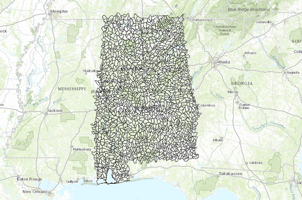
- Watershed Boundary Dataset (WBD) (12-digit HUC, level 6, Alabama, USA)
Watershed Boundary Dataset (WBD) (12-digit HUC, level 6, Alabama, USA)
Sep 2, 2014
Uploaded by
Conservation Biology Institute
- Description:
- This data set is a complete digital hydrologic unit boundary layer to the Subwatershed (12-digit) 6th level for the entire United States. This data set consists of geo-referenced digital data and associated attributes created in accordance with the "Federal Guidelines, Requirements, and Procedures for the National Watershed Boundary Dataset; Chapter 3 of Section A, Federal Standards, Book 11, Collection and Delineation of Spatial Data; Techniques and Methods 11-A3" (04/01/2009). http://www.ncgc.nrcs.usda.gov/products/datasets/watershed/index.html . Polygons are attributed with hydrologic unit codes for 4th level sub-basins, 5th level watersheds, 6th level subwatersheds, name, size, downstream hydrologic unit, type of watershed, non-contributing areas and flow modification.
- Data Provided By:
- Funding and support for the Watershed Boundary Dataset (WBD) were provided by the Natural Resources Conservation Service, the Environmental Protection Agency, and the United States Geological Survey. Representatives from the U.S. Geological Survey and Environmental Protection Agency contributed a substantial amount of time and salary towards quality review and updating of the dataset in order to meet the Federal Standards for Delineation of Hydrologic Unit Boundaries.
- Content date:
- not specified
- Contact Organization:
- not specified
- Contact Person(s):
- not specified
- Use Constraints:
 This work is licensed under a Creative Commons Attribution 3.0 License.
- Layer:
- Layer Type:
- Currently Visible Layer:
- All Layer Options:
- Layers in this dataset are based on combinations of the following options. You may choose from these options to select a specific layer on the map page.
- Description:
- Spatial Resolution:
- Credits:
- Citation:
- Purpose:
- Methods:
- References:
- Other Information:
- Time Period:
- Layer Accuracy:
- Attribute Accuracy:
FGDC Standard Metadata XML
Click here to see the full FGDC XML file that was created in Data Basin for this layer.
Original Metadata XML
Click here to see the full XML file that was originally uploaded with this layer.
This dataset is visible to everyone
- Dataset Type:
-
Layer Package
Downloaded by
24 Members
Bookmarked by
1 Member
,
2 Groups
Included in
4 Public Maps
,
3 Private Maps
About the Uploader
Conservation Biology Institute
We provide advanced conservation science, technology, and planning to empower our partners in solving the world’s critical ecological challenges