- Data Basin |
- Datasets |
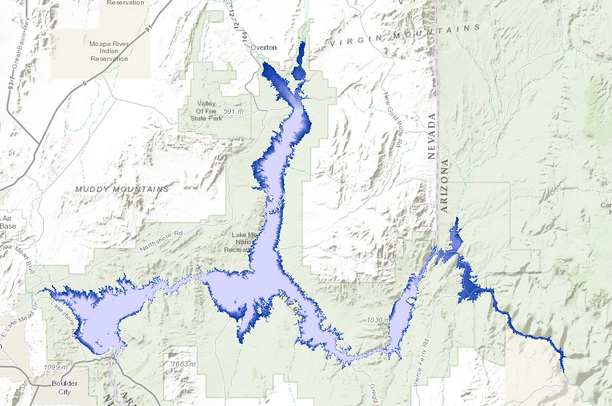
- Lake Mead Shoreline Elevation 1220' - 1100'
Lake Mead Shoreline Elevation 1220' - 1100'
Apr 1, 2015
(Last modified Jun 13, 2015)
Uploaded by
Kerry Gaiz
- Description:
- Polygons representing Lake Mead (Arizona and Nevada) at elevations between 1100' and 1220' (high water) in 10' increments. Polygons were generated from polylines created from LIDAR data flown in 2009 along the shoreline of Lake Mead by the U.S. Bureau of Reclamation. Polygons are tied to UTM Zone 11, NAD 83 (HARN), NAVD 88 and not the Hoover Dam powerhouse datum (difference is approximately 2'). Data meets or exceeds National Map Accuracy Standards for 1:12,000. Note: At higher reservoir elevations (1200' and greater), polygons don't fully represent the degree to which the reservoir backs up the Colorado River into Grand Canyon National Park.
- Data Provided By:
- Bureau of Reclamation, National Park Service
- Content date:
- not specified
- Contact Organization:
- not specified
- Contact Person(s):
- Use Constraints:
 This work is licensed under a Creative Commons Attribution 3.0 License.
- Layer:
- Layer Type:
- Currently Visible Layer:
- All Layer Options:
- Layers in this dataset are based on combinations of the following options. You may choose from these options to select a specific layer on the map page.
- Description:
- Spatial Resolution:
- Credits:
- Citation:
- Purpose:
- Methods:
- References:
- Other Information:
- Time Period:
- Layer Accuracy:
- Attribute Accuracy:
FGDC Standard Metadata XML
Click here to see the full FGDC XML file that was created in Data Basin for this layer.
Original Metadata XML
Click here to see the full XML file that was originally uploaded with this layer.
This dataset is visible to everyone
- Dataset Type:
-
Layer Package
Downloaded by
29 Members
Bookmarked by
1 Member
About the Uploader
Kerry Gaiz
Cartographic Technician with Lake Mead National Recreation Area
Resource Management and Visitor Services