- Data Basin |
- Datasets |
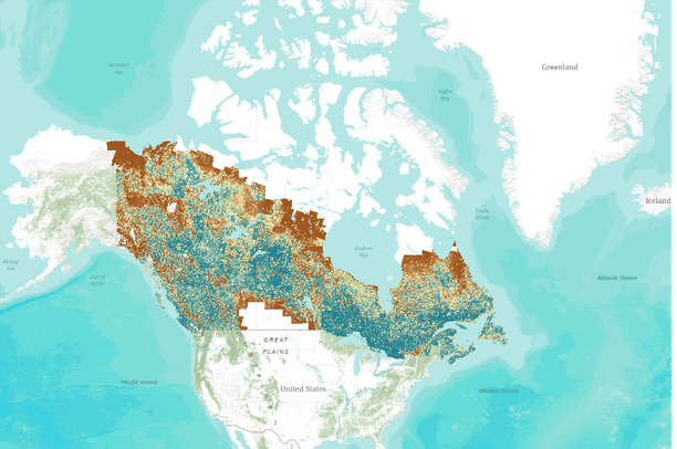
- Canadian Boreal Forest Fragmentation
Canadian Boreal Forest Fragmentation
- Description:
Fragmentation, which is often defined as the breaking apart of habitat (Fleishman and Mac Nally, 2007), represents an important aspect of the landscape spatial pattern and can greatly affect biodiversity. Specifically, forest fragmentation can be characterized by the amount and spatial configuration of forests (Wulder et al., 2009). This dataset comprises of six forest fragmentation metrics, selected from among 90 plus metrics (Wulder et al., 2008), suitable for representing forest fragmentation over large areas: (i) Edge density (m/ha), (ii) Mean patch size [ha], (iii) Number of forest patches, (iv) Proportion of forest patches [%], (v) Relative area [%], (vi) Standard deviation of patch size [ha]. These metrics were calculated using the Earth Observation for Sustainable Development of Forests (EOSD) product (Wulder et al., 2008), and are currently being used in conjunction with other datasets to help characterize ecosystem properties and biodiversity within the Canadian Boreal region (as defined by Brandt (2009)).
Cited references:
Brandt, J. (2009) The extent of the North American boreal zone. Environmental Reviews 17: 101-161. doi:10.1139/A39-004Fleishman, E., and Mac Nally, R. (2007) Measuring the response of animals to contemporary drivers of fragmentation. Candian Journal of Zoology, Vol. 85, No. 10, 1080-1090
Wulder, M.A., White, J., Han, T., Coops, N., Cardille, J., Holland, T., and Grills, D. (2008) Monitoring Canada's forests - Part 2: National forest fragmentation and pattern. Canadian Journal of Remote Sensing 34: 563-584
Wulder, M.A., White, J., Andrew, M.E., Seitz, N.E., and Coops, N.C. (2009). Forest fragmentation, structure, and age characteristics as a legacy of forest management. Forest Ecology and Management 258: 1938–1949
- Data Provided By:
- Integrated Remote Sensing Studio
- Content date:
- not specified
- Citation:
-
Title: Canadian Boreal Forest Fragmentation
Credits: Integrated Remote Sensing Studio
Publication Date: 12/15/2010
Other Citation Info: This dataset represents 6 forest fragmentation metrics from the over 90 metrics calculated in the following manuscript: Wulder, M., White, J., Han, T., Coops, N., Cardille, J., Holland, T., and Grills, D. (2008) Monitoring Canada's forests - Part 2: National forest fragmentation and pattern. Canadian Journal of Remote Sensing 34: 563-584. Furthermore, this dataset was adapted to include only those areas contained within the Canadian Boreal.Online Linkages: http://cfs.nrcan.gc.ca/projects/254/2Description
- Spatial Resolution:
- 1 km
- Contact Organization:
- not specified
- Contact Person(s):
- Use Constraints:
 This work is licensed under a Creative Commons Attribution 3.0 License.
- Layer:
- Layer Type:
- Currently Visible Layer:
- All Layer Options:
- Layers in this dataset are based on combinations of the following options. You may choose from these options to select a specific layer on the map page.
- Description:
- Spatial Resolution:
- Credits:
- Citation:
- Purpose:
- Methods:
- References:
- Other Information:
- Time Period:
- Layer Accuracy:
- Attribute Accuracy:
- Dataset Type:
-
Layer Package
About the Uploader
RESEARCH TOPIC: - Integration of Remote Sensing and Bayesian Modeling for Fine-scale Prediction of Species - Distributions and Reserve Coverage (mol.org) RESEARCH INTEREST - Remote Sensing & GIS- Biodiversity informatics and conservation- Landscape ecology- Wetland/forest landscape modeling and...