- Data Basin |
- Datasets |
- Kit Fox Habitat Suitability Model - Cypher 2013
Kit Fox Habitat Suitability Model - Cypher 2013
Jun 11, 2014
(Last modified Oct 21, 2015)
Uploaded by
Conservation Biology Institute
- Description:
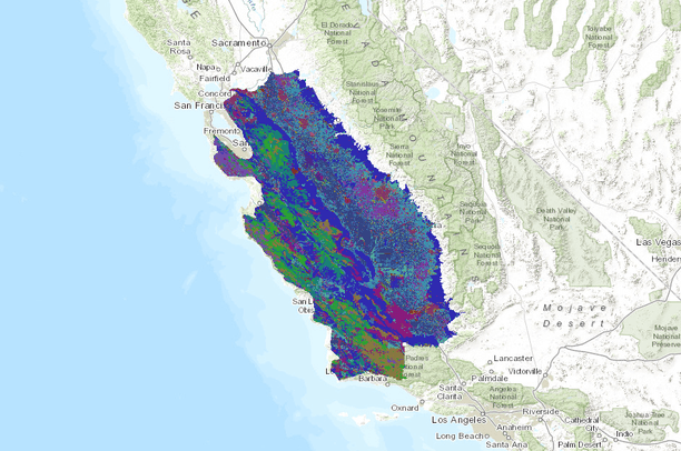
- The San Joaquin kit fox (Vulpes macrotis mutica) is endemic to central California, and is listed as Federally Endangered and California Threatened, primarily due to profound habitat loss. This loss continues and habitat protection is urgently needed for the conservation and eventual recovery of the kit fox. To identify lands to target for habitat protection, we used a GIS-based map-algebra model to determine the distribution of remaining suitable habitat for San Joaquin kit foxes. The primary variables used in the model included land use/land cover, vegetation density, and terrain ruggedness. Suitability was categorized as high, medium, or low based on habitat attributes relative to the presence and persistence of kit fox populations. Model results indicated that only 4,140 km2 of high suitability habitat and 7,268 km2 of medium suitability habitat remain for San Joaquin kit foxes, and much of this habitat is highly fragmented. High suitability habitat primarily is concentrated in the southern portion of the kit fox range with some also scattered along the western edge of the San Joaquin Valley. Persistent kit fox populations appear to occur only in areas with relatively large patches of high suitability habitat or a mix of high and medium suitability habitat. Kit fox populations are apparently unable to persist in areas with high habitat fragmentation or areas with primarily medium suitability habitat. Our results underscore the urgent need to focus protection efforts on high suitability habitat and to do so in a manner that increases patch size of protected lands.
- Data Provided By:
- Downloaded from the UC Davis Information Center for the Environment (ICE). Model created by Cypher 2013
- Content date:
- not specified
- Contact Organization:
- not specified
- Contact Person(s):
- not specified
- Use Constraints:
 This work is licensed under a Creative Commons Attribution 3.0 License.
- Layer:
- Layer Type:
- Currently Visible Layer:
- All Layer Options:
- Layers in this dataset are based on combinations of the following options. You may choose from these options to select a specific layer on the map page.
- Description:
- Spatial Resolution:
- Credits:
- Citation:
- Purpose:
- Methods:
- References:
- Other Information:
- Time Period:
- Layer Accuracy:
- Attribute Accuracy:
FGDC Standard Metadata XML
Click here to see the full FGDC XML file that was created in Data Basin for this layer.
Original Metadata XML
Click here to see the full XML file that was originally uploaded with this layer.
This dataset is visible to everyone
- Dataset Type:
-
Layer Package
Downloaded by
33 Members
Bookmarked by
3 Members
,
3 Groups
Included in
1 Public Map
,
2 Private Maps
Included in
4 Public Galleries
,
1 Private Gallery
About the Uploader
Conservation Biology Institute
We provide advanced conservation science, technology, and planning to empower our partners in solving the world’s critical ecological challenges