- Data Basin |
- Datasets |
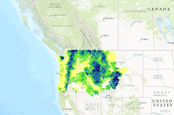
- Pacific Northwest Riparian Climate Corridors: scores attributed to HUC-6 watersheds
Pacific Northwest Riparian Climate Corridors: scores attributed to HUC-6 watersheds
Apr 13, 2015
(Last modified Aug 22, 2017)
Uploaded by
North Pacific LCC Data Coordinator
This map service is unavailable
- Description:
- These layers were produced as part of the WGA/LCC Riparian Mapping Project, which identified riparian location, condition, and climate adaptation potential, for the Pacific Northwest, USA. These layers identify potential riparian areas (i.e., near-stream valley bottoms; Theobald et al. 2013) that span large temperature gradients, have high canopy cover, low solar insolation, and low levels of human modification – characteristics expected to facilitate climate-induced species range shifts and provide micro-climatic refugia from warming. Detailed description of the project rationale, methods, and resulting layers may be found in Krosby et al. (2014). References: Krosby, M., Norheim, R., Theobald, D. M., and B. H. McRae. 2014. Riparian Climate-Corridors: Identifying priority areas for conservation in a changing climate. Theobald, D. M., Mueller, D., and J. Norman. 2013. Detailed datasets on riparian and valley-bottom attributes and condition for the Great Northern and Northern Pacific LCC (WRR17).
- Data Provided By:
- not specified
- Data Hosted by:
- ScienceBase (USGS) View Record
- Map Service URL:
- https://www.sciencebase.gov/arcgis/rest/services/Catalog/53c96d58e4b092c1b2565867/MapServer/
- Content date:
- not specified
- Contact Organization:
- not specified
- Contact Person(s):
- not specified
- Use Constraints:
 This work is licensed under a Creative Commons Attribution 3.0 License.
- Layer:
- Layer Type:
- Currently Visible Layer:
- All Layer Options:
- Layers in this dataset are based on combinations of the following options. You may choose from these options to select a specific layer on the map page.
- Description:
- Spatial Resolution:
- Credits:
- Citation:
- Purpose:
- Methods:
- References:
- Other Information:
- Time Period:
- Layer Accuracy:
- Attribute Accuracy:
FGDC Standard Metadata XML
Click here to see the full FGDC XML file that was created in Data Basin for this layer.
Original Metadata XML
Click here to see the full XML file that was originally uploaded with this layer.
This dataset is visible to everyone
- Dataset Type:
-
External Map Service (ArcGIS)
Bookmarked by
2 Members
,
2 Groups
Included in
1 Private Map
Included in
1 Public Gallery
[{"url": "https://www.sciencebase.gov/catalog/file/get/53c96d58e4b092c1b2565867", "title": "Download All Attached Files from ScienceBase"}, {"url": "https://www.sciencebase.gov/catalog/file/get/53c96d58e4b092c1b2565867?f=__disk__57%2F75%2Fd0%2F5775d0ff3a682a524ba035d1af92a2744ad3c9c9", "title": "Theobald et al. 2013 - Detailed datasets on riparian and valley-bottom attributes and condition.pdf"}, {"url": "https://www.sciencebase.gov/catalog/file/get/53c96d58e4b092c1b2565867?f=__disk__08%2F6e%2F8b%2F086e8b84fecb3f9b5013b3ba1799da92018b02f4", "title": "Riparian_March2015Version.gdb.zip"}, {"url": "https://www.sciencebase.gov/catalog/file/get/53c96d58e4b092c1b2565867?f=__disk__f7%2Fbb%2F8d%2Ff7bb8d5e33daba2bcf02ebee0f91985ecd6ac2cd", "title": "Krosby et al 2015.pdf"}]
About the Uploader
North Pacific LCC Data Coordinator
with NPLCC
The North Pacific Landscape Conservation Cooperative promotes development, coordination, and dissemination of science to inform landscape level conservation and sustainable resource management in the face of a changing climate and related stressors