- Data Basin |
- Datasets |
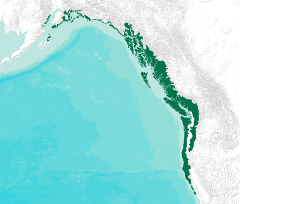
- Coastal Temperate Rain Forest of Western North America - Original Distribution
Coastal Temperate Rain Forest of Western North America - Original Distribution
May 12, 2010
Uploaded by
Conservation Biology Institute
- Description:
- This dataset represents the probable original (prior to European settlement) distribution of the coastal temperate rain forest of western North America.
Excerpt from "The Rain Forests of Home: An Atlas of People and Place. Part 1: Natural Forests and Native Languages of the Coastal Temperate Rainforest" (p. 11): Different methods were used throughout the range of coastal temperate rain forest to delineate probable original extent, depending on information availability. For British Columbia, the coastal western hemlock zone from the Ministry of Forest's biogeoclimatic zone classification was used to determine the temperate rain forest zone. The coast redwood zone was also mapped, based on a data layer of vegetation cover types of California. Outside British Columbia and California, areas having at least 1400 millimeters average annual precipitation were combined with areas having a mean annual temperature range of less than 22 degrees Celsius to distinguish temperate from wet boreal forests. The combined dataset, showing wet temperate areas, was then filtered with elevation data to exclude areas above 3,000 feet, which would be snow-dominated during winter. Areas of permanent snow and ice at the northern end of the range and non-forest areas (barren, shrub-dominated, and rock) were filtered out using generalized land cover data (based on the NDVI data set from the AVHRR satellite sensor). The resulting layer, combined with the coastal western hemlock biogeoclimatic zone for British Columbia and the redwood zone for California, represents the probable pre-European settlement distribution of coastal temperate rain forest.
- Data Provided By:
- Ecotrust, Pacific GIS, Conservation International
- Content date:
- not specified
- Citation:
-
Title: Coastal Temperate Rain Forest of Western North America - Original Distribution
Credits: Ecotrust, Pacific GIS, Conservation International
Publication Date: 1995
Publisher: The Rain Forests of Home: An Atlas of People and Place. Part 1: Natural Forests and Native Languages of the Coastal Temperate Rainforest.
Larger Works:
Title: The Rain Forests of Home: An Atlas of People and Place. Part 1: Natural Forests and Native Languages of the Coastal Temperate Rainforest.
Credits: Ecotrust, Pacific GIS, Conservation International
Publication Date: 1995
Publisher: Ecotrust, Pacific GIS, and Conservation International
- Contact Organization:
- EcoTrust
- Contact Person(s):
- not specified
- Use Constraints:
 This work is licensed under a Creative Commons Attribution 3.0 License.
- Layer:
- Layer Type:
- Currently Visible Layer:
- All Layer Options:
- Layers in this dataset are based on combinations of the following options. You may choose from these options to select a specific layer on the map page.
- Description:
- Spatial Resolution:
- Credits:
- Citation:
- Purpose:
- Methods:
- References:
- Other Information:
- Time Period:
- Layer Accuracy:
- Attribute Accuracy:
FGDC Standard Metadata XML
Click here to see the full FGDC XML file that was created in Data Basin for this layer.
Original Metadata XML
Click here to see the full XML file that was originally uploaded with this layer.
This dataset is visible to everyone
- Dataset Type:
-
Layer Package
Downloaded by
40 Members
Bookmarked by
8 Members
Included in
2 Public Maps
,
3 Private Maps
About the Uploader
Conservation Biology Institute
We provide advanced conservation science, technology, and planning to empower our partners in solving the world’s critical ecological challenges