- Data Basin |
- Datasets |
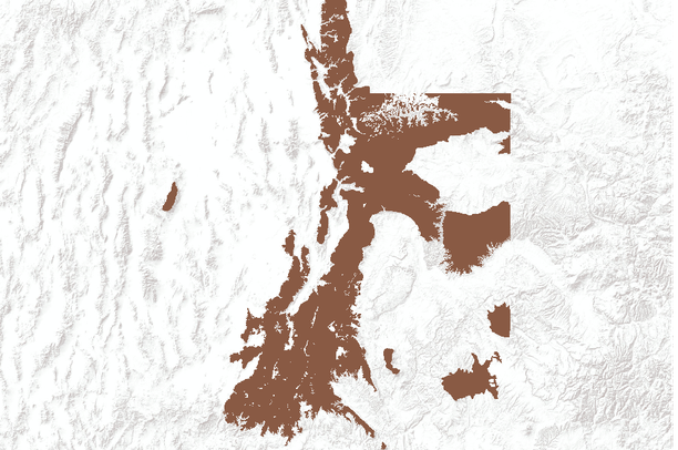
- Black bear use areas in Utah, USA
Black bear use areas in Utah, USA
Feb 7, 2011
(Last modified May 14, 2011)
Uploaded by
Conservation Biology Institute
- Description:
- This dataset represents BLACK BEAR use areas throughout Utah. Between August 2005 and April 2006, field biologists reviewed and critiqued a black bear habitat model based on the 1995 Utah GAP product. During May 2006 the black bear data was converted from a Critical, High, Substantial, and Limited value system to a Crucial/Substantial value system.
- Data Provided By:
- Utah Division of Wildlife Resources
- Content date:
- not specified
- Spatial Resolution:
- Digital data at 1:100,000
- Contact Organization:
- Utah Division of Wildlife Resources
- Contact Person(s):
- not specified
- Use Constraints:
- None. The UDWR provides no warranty, nor accepts any liability, occurring from any incorrect, incomplete, or misleading data, or from any incorrect, incomplete, or misleading use of these data.
- Layer:
- Layer Type:
- Currently Visible Layer:
- All Layer Options:
- Layers in this dataset are based on combinations of the following options. You may choose from these options to select a specific layer on the map page.
- Description:
- Spatial Resolution:
- Credits:
- Citation:
- Purpose:
- Methods:
- References:
- Other Information:
- Time Period:
- Layer Accuracy:
- Attribute Accuracy:
FGDC Standard Metadata XML
Click here to see the full FGDC XML file that was created in Data Basin for this layer.
Original Metadata XML
Click here to see the full XML file that was originally uploaded with this layer.
This dataset is visible to everyone
- Dataset Type:
-
Layer Package
Downloaded by
2 Members
Bookmarked by
1 Member
Included in
1 Private Map
Included in
1 Public Gallery
,
1 Private Gallery
About the Uploader
Conservation Biology Institute
We provide advanced conservation science, technology, and planning to empower our partners in solving the world’s critical ecological challenges