- Data Basin |
- Datasets |
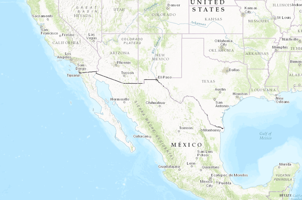
- US-Mexico Border Fence System
US-Mexico Border Fence System
Apr 12, 2017
Uploaded by
Juan Carlos Bravo
- Description:
- US Border Fence System on the US-Mexico border. Non categorized stretches of infrastructure.
- Data Provided By:
- Michael Corey
- Content date:
- 2012
- Citation:
- Corey, Michael 2014, Center for Investigative Reporting
- Contact Organization:
- Center for Investigative Reporting
- Contact Person(s):
- Use Constraints:
 This work is licensed under a Creative Commons Attribution 3.0 License.
- Layer:
- Layer Type:
- Currently Visible Layer:
- All Layer Options:
- Layers in this dataset are based on combinations of the following options. You may choose from these options to select a specific layer on the map page.
- Description:
- Spatial Resolution:
- Credits:
- Citation:
- Purpose:
- Methods:
- References:
- Other Information:
- Time Period:
- Layer Accuracy:
- Attribute Accuracy:
FGDC Standard Metadata XML
Click here to see the full FGDC XML file that was created in Data Basin for this layer.
Original Metadata XML
Click here to see the full XML file that was originally uploaded with this layer.
This dataset is visible to everyone
- Dataset Type:
-
Layer Package
Downloaded by
6 Members
Bookmarked by
2 Members
Included in
1 Public Gallery
https://www.openstreetmap.org/relation/2266294
About the Uploader
Juan Carlos Bravo
Director of the Mexico Program with Wildlands Network
As Wildlands Network’s Director the Mexico Program, I work to expand the Western Wildway into the northern Sierra Madre Occidental by partnering with Mexican groups and improving Wildlands Network’s understanding of the connectivity issues in Mexico. I adapt WN’s overall strategy to a significantly...