- Data Basin |
- Datasets |
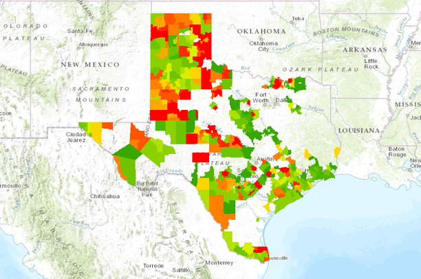
- Texas Land Use Trends - 10 Year Percent Change
Texas Land Use Trends - 10 Year Percent Change
Apr 9, 2014
Uploaded by
Gulf Coast Prairie LCC
- Description:
- At 92.6 million acres, native rangeland continues to be the prevailing general category of land use in Texas. Since 1997, the accumulated localized losses of native rangeland have exceeded 4.8 million acres. In addition, the statewide area in dry (non-irrigated) cropland has declined by 1.57 million acres.
One of the most notable trends continues to be the conversion of native rangelands and croplands to non-native pastures. Non-native pastures now account for over 11 million acres and are the third largest land use category in the state.
A more recent trend in land use is a shift to “wildlife management” following state legislation in 1996 that created the official land use category for tax appraisal purposes. Since then, lands classified as being in wildlife management have increased to 2.37 million acres. Some of the local decline can be attributed to the shift in reporting native rangeland as wildlife management.
- Data Provided By:
- Wilkins, R. Neal, Amy G. Snelgrove, Blair C. Fitzsimons, Brent M. Stevener, Kevin L. Skow, Ross E. Anderson, Amanda M. Dube. "Texas Land Trends." Texas A&M Institute of Renewable Natural Resources. 2009. Texas A&M University.
- Content date:
- not specified
- Citation:
- Texas Land Trends
- Contact Organization:
- Institute of Renewable Natural Resources
- Contact Person(s):
- not specified
- Use Constraints:
 This work is licensed under a Creative Commons Attribution 3.0 License.
- Layer:
- Layer Type:
- Currently Visible Layer:
- All Layer Options:
- Layers in this dataset are based on combinations of the following options. You may choose from these options to select a specific layer on the map page.
- Description:
- Spatial Resolution:
- Credits:
- Citation:
- Purpose:
- Methods:
- References:
- Other Information:
- Time Period:
- Layer Accuracy:
- Attribute Accuracy:
FGDC Standard Metadata XML
Click here to see the full FGDC XML file that was created in Data Basin for this layer.
Original Metadata XML
Click here to see the full XML file that was originally uploaded with this layer.
This dataset is visible to everyone
- Dataset Type:
-
Layer Package
Downloaded by
4 Members
Bookmarked by
1 Group
Included in
1 Public Map
Included in
2 Public Galleries
About the Uploader
Gulf Coast Prairie LCC
with Gulf Coast Prairie Landscape Conservation Cooperative
This is the admin account for the Gulf Coast Prairie LCC Conservation Planning Atlas