- Data Basin |
- Datasets |
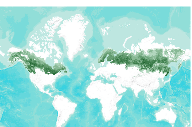
- Percent Forest cover in the Boreal Forest biome (2000)
Percent Forest cover in the Boreal Forest biome (2000)
Jul 16, 2010
Uploaded by
Conservation Biology Institute
- Description:
- This dataset represents forest cover extent for the biome for year 2000. Forests were defined as areas with tree canopy cover greater than 25%. The Landsat-analyzed sample block classification results were used to calibrate biome-wide MODIS-derived forest extent. The relationship between Landsat-based forest cover area and mean VCF tree canopy density per sample block 18.5 km per side was used to derive forest extent for year 2000. A simple linear regression (no intercept) model was used with mean VCF tree canopy density per block as the independent variable.
Data is displayed in grid format, with the value being percent forest cover per pixel.
- Data Provided By:
- Potapov P., Hansen M.C., Stehman S.V., Loveland T.R., Pittman K.
- Content date:
- 2000
- Citation:
-
Title: Percent Forest cover in the Boreal Forest biome (2000)
Credits: Potapov P., Hansen M.C., Stehman S.V., Loveland T.R., Pittman K.
Online Linkages: Other Citation Info: Potapov P., Hansen M. C., Stehman S. V., Loveland T. R., Pittman K. (2008) Combining MODIS and Landsat imagery to estimate and map boreal forest cover loss. Remote Sensing of Environment, 112(9), 3708-3719.
- Contact Organization:
- Geographic Information Science Center of Excellence - SDSU
- Contact Person(s):
- Use Constraints:
- Provided MODIS-derived data are available for use for valid scientific, conservation, and educational purposes as long as proper citations are used. We ask that you credit the Boreal Forest Monitoring data as follows: Potapov P., Hansen M. C., Stehman S. V., Loveland T. R., Pittman K. (2008) Combining MODIS and Landsat imagery to estimate and map boreal forest cover loss. Remote Sensing of Environment, 112(9), 3708-3719.
- Layer:
- Layer Type:
- Currently Visible Layer:
- All Layer Options:
- Layers in this dataset are based on combinations of the following options. You may choose from these options to select a specific layer on the map page.
- Description:
- Spatial Resolution:
- Credits:
- Citation:
- Purpose:
- Methods:
- References:
- Other Information:
- Time Period:
- Layer Accuracy:
- Attribute Accuracy:
FGDC Standard Metadata XML
Click here to see the full FGDC XML file that was created in Data Basin for this layer.
Original Metadata XML
Click here to see the full XML file that was originally uploaded with this layer.
This dataset is visible to everyone
- Dataset Type:
-
Layer Package
Downloaded by
27 Members
Bookmarked by
2 Members
,
1 Group
Included in
4 Private Maps
About the Uploader
Conservation Biology Institute
We provide advanced conservation science, technology, and planning to empower our partners in solving the world’s critical ecological challenges