- Data Basin |
- Datasets |
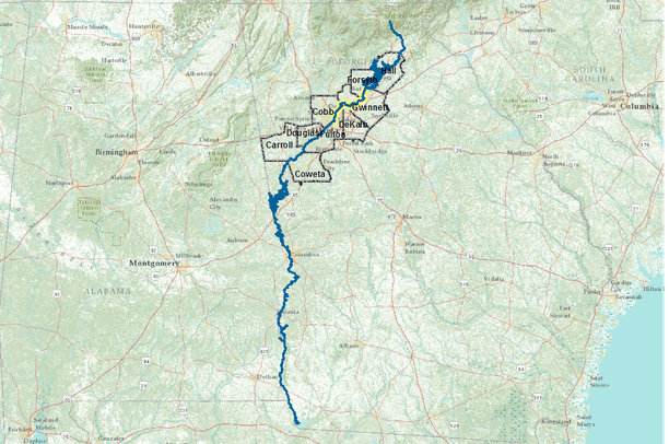
- Chattahoochee River - Recreation Access
Chattahoochee River - Recreation Access
Mar 16, 2012
(Last modified Mar 20, 2012)
Uploaded by
Brenda Faber
- Description:
- On February 29, 2012 Secretary of the Interior Ken Salazar unveiled the National Water Trails System , a new network that will increase access to water-based outdoor recreation, encourage community stewardship of local waterways, and promote tourism that fuels local economies across America. The Chattahoochee River Water Trail in Georgia was the first river to be designated as a National Water Trail System under the new program.
This dataset explores opportunities and needs to expand the Chattahoochee River Water Trail beyond its current extent.
- Data Provided By:
-
This dataset was assembled by The Trust for Public Land
- National GIS Office. See individual layers for data credits.
- Content date:
- 200607, 200612
- Citation:
-
https://gis1.state.ga.us/download.asp?dataID=40678
http://gis1.state.ga.us/download.asp?dataID=4496
http://protectedareas.consbio.org/
http://gis1.state.ga.us/download.asp?dataID=40670
http://gis1.state.ga.us/download.asp?dataID=4319
- Contact Organization:
-
Georgia Institute of Technology, Center for Geographic Information Systems (CGIS)
Georgia GIS Data Clearinghouse
Atlanta Regional Commission
U.S. Department of Commerce, U.S. Census Bureau, Geography Division, Geographic Products Management Branch
Conservation Biology Institute
- Contact Person(s):
- Use Constraints:
 This work is licensed under a Creative Commons Attribution-NonCommercial 3.0 License.
- Layer:
- Layer Type:
- Currently Visible Layer:
- All Layer Options:
- Layers in this dataset are based on combinations of the following options. You may choose from these options to select a specific layer on the map page.
- Description:
- Spatial Resolution:
- Credits:
- Citation:
- Purpose:
- Methods:
- References:
- Other Information:
- Time Period:
- Layer Accuracy:
- Attribute Accuracy:
FGDC Standard Metadata XML
Click here to see the full FGDC XML file that was created in Data Basin for this layer.
Original Metadata XML
Click here to see the full XML file that was originally uploaded with this layer.
This dataset is visible to everyone
- Dataset Type:
-
Layer Package
Downloaded by
39 Members
Bookmarked by
1 Member
Included in
3 Public Maps
,
3 Private Maps