- Data Basin |
- Datasets |
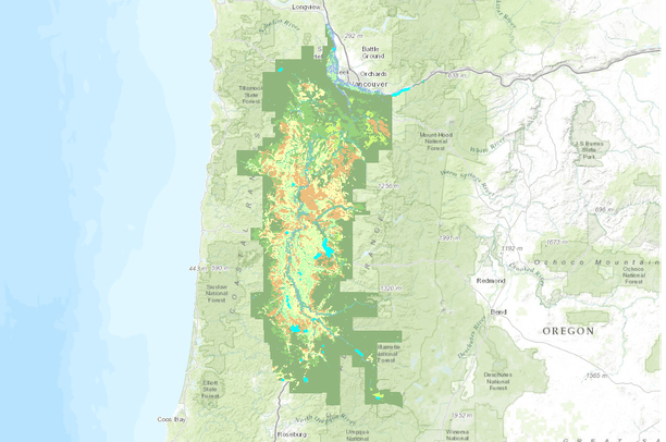
- Willamette Valley Pre Settlement Vegetation 1850
Willamette Valley Pre Settlement Vegetation 1850
Apr 19, 2013
(Last modified Jul 27, 2015)
Uploaded by
Jonathan Pope
- Description:
- This map is a reinterpretation of a more extensive set of polygons demonstrating estimated original (pre 1850) vegetation types for the Willamette Valley. Vegetation type classifications were simplified and recombined for ease of comparison with currently used classifications: i.e. Shrubland, willow swamp was joined with other wetland types, though areas with that original designation can still be found using the "Information" function in ArcMap.
The vegetation polygons can be laid over a basemap of current road system for use in comparing original vegetation with current vegetation status, and for locating extant remnants of original plant communities.
I believe that the information contained within these polygons, generated through years of mapping reasearch, beginning in the late 1840's, can be of great value in understanding the botanical and ecological heritage of the Willamette Valley.
I stumbled upon this data while researching the ecological history of my property. It appeared to me to be informative for not only understanding our ecological heritage (as each vegetation layer also represents a zone within the larger ecosystem), but also for planning future actions, particularly in regard to habitat restoration efforts, park planning, the planning of development and infratstructure as well. The more we respect the natural potential of any given microenvrionment, the more able we are to maintain its inherent ecological values, including it's value to be a place of inspiration and rejuvenation for our own species.
Source data (see credits below) were reorganized to utilize current and generally familiar and useful vegetation classification designations, including Forest types, Woodland types, Prairie types, Savanna types, Wetland types.
It is based on land survey data recorded by General Land Office (GLO) surveyors between 1851 and 1910, including township and section line data."
- Data Provided By:
-
U.S. General Land Office surveyors and cartographers from 1848-1910. Christy, J.A., E.R. Alverson, M.P. Dougherty, S.C. Kolar, C.W. Alton, S.M. Hawes, L. Ashkenas & P. Minear. 2011. GLO historical vegetation of the Willamette Valley, Oregon, 1851-1910. ArcMap shapefile, Version 2011_04. Oregon Biodiversity Information Center, Portland State University. http://pdx.edu/pnwlamp/glo-historical-vegetation-maps-for-oregon-0John Ritter, Professor of Geomantics, Oregon Institute of Technology, Klamath Falls, Oregon: John contributed by providing a one-week crash course in GIS mapping to K-12 teachers, and providing me with advice and assistance over the period of several years.
- Content date:
- 1851, 1910
- Contact Organization:
- not specified
- Contact Person(s):
- not specified
- Use Constraints:
 This work is licensed under a Creative Commons Attribution 3.0 License.
- Layer:
- Layer Type:
- Currently Visible Layer:
- All Layer Options:
- Layers in this dataset are based on combinations of the following options. You may choose from these options to select a specific layer on the map page.
- Description:
- Spatial Resolution:
- Credits:
- Citation:
- Purpose:
- Methods:
- References:
- Other Information:
- Time Period:
- Layer Accuracy:
- Attribute Accuracy:
FGDC Standard Metadata XML
Click here to see the full FGDC XML file that was created in Data Basin for this layer.
Original Metadata XML
Click here to see the full XML file that was originally uploaded with this layer.
This dataset is visible to everyone
- Dataset Type:
-
Layer Package
Downloaded by
70 Members
Bookmarked by
5 Members
,
4 Groups
Included in
8 Public Maps
,
13 Private Maps
Included in
1 Private Gallery
About the Uploader
Jonathan Pope
Adjunct Instructor in STEM Education with Pacific University, Forest Grove, Oregon
I became interested in GPS and mapping through a class offered by the Oregon Institute of Technology. SInce then I've initiated my own mapping research project on 4 acres near Brooks, Oregon, utilizing ArcMap and ArcPad software, to discover the native plant and animal species utilizing that land....