- Data Basin |
- Datasets |
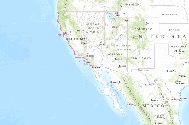
- California Coastal Zone Map
California Coastal Zone Map
May 20, 2015
Uploaded by
PacificSouthwestRegion
This map service is unavailable
- Description:
- California Coastal Zone means that land and water area of the State of California from the Oregon border to the border of the Republic of Mexico, extending seaward to the state's outer limit of jurisdiction, including all offshore islands, and extending inland generally 1,000 yards from the mean high tide line of the sea. In significant coastal estuarine, habitat, and recreational areas it extends inland to the first major ridgeline paralleling the sea or five miles from the mean high tide line of the sea, whichever is less, and in developed urban areas the zone generally extends inland less than 1,000 yards. The coastal zone does not include the area of jurisdiction of the San Francisco Bay Conservation and Development Commission, nor any area contiguous thereto, including any river, stream, tributary, creek, or flood control or drainage channel flowing into such area.
- Data Provided By:
- California Coastal Commission
- Map Service URL:
- https://gis.cnra.ca.gov/arcgis/rest/services/Boundaries/Coastal_Conservancy/MapServer/
- Content date:
- not specified
- Contact Organization:
- California Coastal Commission
- Contact Person(s):
- not specified
- Use Constraints:
- the California Coastal Commission (http://www.coastal.ca.gov)
- Layer:
- Layer Type:
- Currently Visible Layer:
- All Layer Options:
- Layers in this dataset are based on combinations of the following options. You may choose from these options to select a specific layer on the map page.
- Description:
- Spatial Resolution:
- Credits:
- Citation:
- Purpose:
- Methods:
- References:
- Other Information:
- Time Period:
- Layer Accuracy:
- Attribute Accuracy:
FGDC Standard Metadata XML
Click here to see the full FGDC XML file that was created in Data Basin for this layer.
Original Metadata XML
Click here to see the full XML file that was originally uploaded with this layer.
This dataset is visible to everyone
- Dataset Type:
-
External Map Service (ArcGIS)
Bookmarked by
4 Members
Included in
7 Public Maps
,
13 Private Maps
Included in
1 Public Gallery
About the Uploader
PacificSouthwestRegion
Multiple Administrators with US Fish and Wildlife Service
This US Fish and Wildlife User Group is responsible for maintaining the Pacific Southwest Region Web Mapping Portal