- Data Basin |
- Datasets |
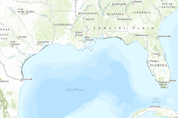
- Gulf of Mexico Barrier Islands
Gulf of Mexico Barrier Islands
Jan 30, 2015
Uploaded by
Gulf Coast Prairie LCC
- Description:
- Barrier Island maps were derived from NOS shorelines. First, a selection of barrier-island NOS shoreline of the U.S. Gulf of Mexico was made. Shorelines were dissolved and gaps between lines were closed. Line data was transformed to polygon data using ET Geowizard ArcGIS extension. Final polygons were edited as necessary and small residual features were removed. Barrier names were assigned using GNIS and R.A. Davis' book as resources.
- Data Provided By:
- Harte Research Institute for Gulf of Mexico Studies - Coastal and Marine Geospatial Lab, Department of Commerce (DOC), National Oceanic and Atmospheric Administration (NOAA), National Ocean Service (NOS), Coastal Services Center (CSC)
- Content date:
- not specified
- Contact Organization:
- Harte Research Institute for Gulf of Mexico Studies - Coastal and Marine Geospatial Lab
- Contact Person(s):
- Use Constraints:
 This work is licensed under a Creative Commons Attribution 3.0 License.
- Layer:
- Layer Type:
- Currently Visible Layer:
- All Layer Options:
- Layers in this dataset are based on combinations of the following options. You may choose from these options to select a specific layer on the map page.
- Description:
- Spatial Resolution:
- Credits:
- Citation:
- Purpose:
- Methods:
- References:
- Other Information:
- Time Period:
- Layer Accuracy:
- Attribute Accuracy:
FGDC Standard Metadata XML
Click here to see the full FGDC XML file that was created in Data Basin for this layer.
Original Metadata XML
Click here to see the full XML file that was originally uploaded with this layer.
This dataset is visible to everyone
- Dataset Type:
-
Layer Package
Downloaded by
17 Members
About the Uploader
Gulf Coast Prairie LCC
with Gulf Coast Prairie Landscape Conservation Cooperative
This is the admin account for the Gulf Coast Prairie LCC Conservation Planning Atlas