- Data Basin |
- Datasets |
- Omnidirectional Connectivity for Resilient Terrestrial Landscapes in the Pacific Northwest
Omnidirectional Connectivity for Resilient Terrestrial Landscapes in the Pacific Northwest
May 5, 2017
Uploaded by
Aaron Jones
Dataset was reviewed in another manner
- Description:
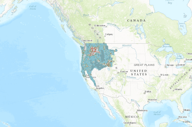
- This broad-scale (up to 50km) landscape connectivity analysis, identifies areas likely to facilitate ecological flow—particularly movement, dispersal, gene flow, and distributional range shifts for terrestrial plants and animals—over large distances and long time periods. Similar to the local permeability analyses (3km radius, Buttrick et al. 2015), this analysis is not species-specific. Rather, it focuses on structural connectivity of natural lands, with resistance to movement modeled as a function of landscape naturalness. This map does not incorporate projections of future climates, nor does it address connectivity for aquatic species. The results identify broad, intact areas where movement of terrestrial organisms is largely unrestricted by human modifications to the landscape, as well as constricted areas where fragmentation has reduced movement options and further habitat loss could isolate remaining natural lands.
This map represents OmniScape current flow normalized by regional flow potential. Regional Flow Potential indicates how much current flow would be expected in the absence of barriers, and is proportional to the amount of natural land within the focal window. Upper and lower extremes of regional flow potential are overlaid in this map in order to highlight areas with the most and least natural land to connect, respectively. This helps to distinguish 1) broad, intact areas where movement is diffuse or largely unrestricted, 2) channeled areas or pinch points where further habitat loss could isolate natural areas, and 3) areas where flow is impeded by barriers.
OmniScape, a moving window implementation of CircuitScape, represents a landscape as a resistive surface. Landscape features conducive to movement are given low resistances, and features that act as barriers to movement are given higher resistances. Similarly, a source weight surface is constructed with greater source weights assigned to pixels in more natural condition. OmniScape utilizes these surfaces to model the current flow between all semi-natural lands in the focal window, with higher current flow occurring between areas with high source weights and along paths of low resistance. More details are available from McRae et al. 2016.
These data are part of a land facet terrestrial resilience project created for the Pacific Northwest to identify the most resilient terrestrial sites in the Northwest U.S. that will collectively and individually best sustain native biodiversity even as the changing climate alters current distribution patterns. The central idea is that by mapping key geophysical features and evaluating them for landscape characteristics that buffer against the effects of climate change, we can identify the most resilient places in order to guide future conservation investments. All the datasets, along with the full report containing methods and maps are available at: http://nature.org/resilienceNW
See a gallery of all datasets from the Conserving Nature’s Stage project on Data Basin:http://nplcc.databasin.org/galleries/e41a3ea84e78463bbf9f03ce2f8e9205
- Data Provided By:
- The Nature Conservancy
- Content date:
- Decadal timeframes
- Citation:
- McRae, B.H., K. Popper, A. Jones, M. Schindel, S. Buttrick, K. Hall, R.S. Unnasch, and J. Platt. 2016. Conserving Nature’s Stage: Mapping Omnidirectional Connectivity for Resilient Terrestrial Landscapes in the Pacific Northwest. The Nature Conservancy, Portland Oregon. 47 pp. Available online at: http://nature.org/resilienceNW June 30, 2016.
- Spatial Resolution:
- 90 / 180 (meters)
- Contact Organization:
- The Nature Conservancy
- Contact Person(s):
- Use Constraints:
- Copyright © 2016 The Nature Conservancy. All rights reserved. Aquatic resources such as rivers and lakes should not be evaluated with these data. Near-shore marine areas including estuaries and small islands should also not be evaluated with these data, as tides, oceanic climate and sea-level rise may confound analyses built upon terrestrial data inputs and assumptions.The Nature Conservancy shall not be held liable for improper or incorrect use of the data described and/or contained herein. Any sale, distribution, loan, or offering for use of these digital data, in whole or in part, is prohibited without the approval of the Nature Conservancy. The use of these data to produce other GIS products and services with the intent to sell for a profit is prohibited without the written consent of the Nature Conservancy. All parties receiving these data must be informed of these restrictions. The Nature Conservancy shall be acknowledged as data contributors to any reports or other products derived from these data.
- Layer:
- Layer Type:
- Currently Visible Layer:
- All Layer Options:
- Layers in this dataset are based on combinations of the following options. You may choose from these options to select a specific layer on the map page.
- Description:
- Spatial Resolution:
- Credits:
- Citation:
- Purpose:
- Methods:
- References:
- Other Information:
- Time Period:
- Layer Accuracy:
- Attribute Accuracy:
FGDC Standard Metadata XML
Click here to see the full FGDC XML file that was created in Data Basin for this layer.
Original Metadata XML
Click here to see the full XML file that was originally uploaded with this layer.
This dataset is visible to everyone
- Dataset Type:
-
Layer Package
Downloaded by
28 Members
Bookmarked by
1 Member
,
9 Groups
Included in
3 Public Maps
,
10 Private Maps
Included in
2 Public Galleries
http://nature.org/resilienceNW