- Data Basin |
- Datasets |
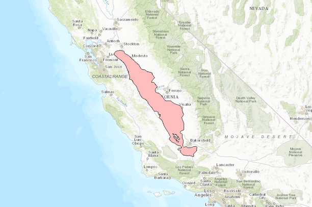
- Extent of Corcoran Clay
Extent of Corcoran Clay
Feb 28, 2017
Uploaded by
Conservation Biology Institute
- Description:
- This digital dataset defines the extent of the Corcoran Clay Member of the Tulare Formation. The complex hydrologic system of the Central Valley is simulated using the USGS numerical modeling code MODFLOW-FMP (Schmid and others, 2006b). This simulation is referred to here as the Central Valley Hydrologic Model (CVHM) (Faunt, 2009). Utilizing MODFLOW-FMP, the CVHM simulates groundwater and surface-water flow, irrigated agriculture, land subsidence, and other key processes in the Central Valley on a monthly basis from 1961-2003. Numerous lenses of fine-grained sediments are distributed throughout the southern Central Valley (San Joaquin Valley) and generally constitute more than 50 percent of the total thickness of the valley fill. Generally, these lenses are discontinuous and not vertically extensive or laterally continuous. However, the Corcoran Clay is a low-permeability, areally extensive, lacustrine deposit (Johnson and others, 1968) as much as 200-ft thick (Davis and others, 1959; Page, 1986). This continuous clay divides the groundwater-flow system of the western San Joaquin Valley into an upper semi-confined zone and a lower confined zone (Williamson and others, 1989; Belitz and Heimes, 1990; Burow and others, 2004). The extent and distribution of the Corcoran Clay was defined for use in the CVHM because the unit is one of the few deposits in the Valley that can be regionally mapped. The CVHM is the most recent regional-scale model of the Central Valley developed by the U.S. Geological Survey (USGS).More information: https://catalog.data.gov/dataset/contours-of-corcoran-clay-depth-in-feet-from-page-1986-for-the-central-valley-hydrologic-model-
- Data Provided By:
- USGS
- Content date:
- not specified
- Contact Organization:
- not specified
- Contact Person(s):
- not specified
- Use Constraints:
 This work is licensed under a Creative Commons Attribution 3.0 License.
- Layer:
- Layer Type:
- Currently Visible Layer:
- All Layer Options:
- Layers in this dataset are based on combinations of the following options. You may choose from these options to select a specific layer on the map page.
- Description:
- Spatial Resolution:
- Credits:
- Citation:
- Purpose:
- Methods:
- References:
- Other Information:
- Time Period:
- Layer Accuracy:
- Attribute Accuracy:
FGDC Standard Metadata XML
Click here to see the full FGDC XML file that was created in Data Basin for this layer.
Original Metadata XML
Click here to see the full XML file that was originally uploaded with this layer.
This dataset is visible to everyone
- Dataset Type:
-
Layer Package
Downloaded by
5 Members
Bookmarked by
1 Member
Included in
1 Private Map
Included in
3 Public Galleries
About the Uploader
Conservation Biology Institute
We provide advanced conservation science, technology, and planning to empower our partners in solving the world’s critical ecological challenges