- Data Basin |
- Datasets |
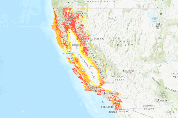
- CAL FIRE FRAP Fire Hazard Severity Zones
CAL FIRE FRAP Fire Hazard Severity Zones
Oct 25, 2019
(Last modified Jul 1, 2022)
Uploaded by
Conservation Biology Institute
Dataset was reviewed in another manner
- Description:
- PRC 4201 - 4204 and Govt. Code 51175-89 direct the California Department of Forestry and Fire Protection (CAL FIRE) to map areas of significant fire hazards based on fuels, terrain, weather, and other relevant factors. These zones, referred to as Fire Hazard Severity Zones (FHSZ), define the application of various mitigation strategies to reduce risk associated with wildland fires. CAL FIRE is remapping Fire Hazard Severity Zones (FHSZ) for State Responsibility Areas (SRA) and Very High Fire Hazard Severity Zones (VHFHSZ) recommendations in Local Responsibility Areas (LRA) to provide updated map zones, based on new data, science, and technology. This specific dataset is used to create the official "Maps of Fire Hazard Severity Zones in the State Responsibility Area of California" as required by Public Resources Code 4201-4204 and entitled in the California Code of Regulation, Title 14, Section 1280 Fire Hazard Severity Zones, and as adopted by CAL FIRE on November 7, 2007Maps of the adopted zones in SRA are available at:
- Data Provided By:
- California Department of Forestry and Fire Protection, Fire and Resource Assessment Program (CALFIRE - FRAP),CAL FIRE - FRAP,CAL FIRE - FRAP
- Content date:
- 2007
- Citation:
-
https://osfm.fire.ca.gov/divisions/community-wildfire-preparedness-and-mitigation/wildland-hazards-building-codes/fire-hazard-severity-zones-maps/See this link for official map hosted by CALFIRE:
- Contact Organization:
- California Department of Forestry and Fire Protection, Fire and Resource Assessment Program (CALFIRE - FRAP),CAL FIRE - FRAP,CAL FIRE - FRAP
- Contact Person(s):
- Use Constraints:
 This work is licensed under a Creative Commons Attribution 3.0 License.
- Layer:
- Layer Type:
- Currently Visible Layer:
- All Layer Options:
- Layers in this dataset are based on combinations of the following options. You may choose from these options to select a specific layer on the map page.
- Description:
- Spatial Resolution:
- Credits:
- Citation:
- Purpose:
- Methods:
- References:
- Other Information:
- Time Period:
- Layer Accuracy:
- Attribute Accuracy:
FGDC Standard Metadata XML
Click here to see the full FGDC XML file that was created in Data Basin for this layer.
Original Metadata XML
Click here to see the full XML file that was originally uploaded with this layer.
This dataset is visible to everyone
- Dataset Type:
-
Layer Package
Downloaded by
70 Members
Bookmarked by
1 Member
,
8 Groups
Included in
7 Public Maps
,
13 Private Maps
Included in
5 Public Galleries
,
2 Private Galleries
About the Uploader
Conservation Biology Institute
We provide advanced conservation science, technology, and planning to empower our partners in solving the world’s critical ecological challenges