- Data Basin |
- Use Cases |
- Current Terrestrial Landscape Intactness Model Dataset
Current Terrestrial Landscape Intactness Model Dataset

Explore related items…
The Current Terrestrial Landscape Intactness Model dataset provides information about the quality of the landscape at any location
The Current Terrestrial Landscape Intactness Model was developed to measure the relative ecological intactness for the Desert Renewable Energy Conservation Plan (DRECP) study area. Intactness is a quantifiable estimate of naturalness according to the level of anthropogenic, or human, influence based on available spatial data (e.g. roads, mines, and agriculture).
The Terrestrial Landscape Intactness Model was created using the Environmental Evaluation Modeling System, otherwise known as EEMS. EEMS is a fuzzy logic, tree-based modeling system which combines spatial data of different types to produce a solution to a main question. EEMS’ ability to integrate multiple measures of landscape development and vegetation intactness means it can answer the question, “Why does a particular location have a low or high terrestrial intactness?” The intactness model provides a regional perspective of natural vegetation condition, level of development, and natural habitat fragmentation patterns. Intactness is high in areas where development is low, natural vegetation quality is high, and natural landscape fragmentation is low. In essence, the intactness model provides a scientifically supported description of the ecological stage. The model used to create the Current Terrestrial Intactness Model is shown below.


To learn more about EEMS, you can view the EEMS Explorer instructional video or read a Guide and Case Study about the EEMS model. To learn how to navigate the Current Terrestrial Landscape Intactness Model dataset, you can view the Current Terrestrial Landscape Intactness introduction video located on the homepage of the DRECP Gateway.
When you open the Current Terrestrial Landscape Intactness dataset, because it has an associated EEMS model, you will see an EEMS explorer icon in the layer tab.
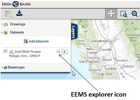
Clicking on the icon opens the EEMS Explorer, an interactive window providing access to the EEMS model. To view the nodes in the EEMS model, you can search by scrolling in the model window or search through the full model view.
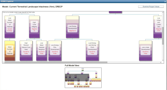
To display the data layer associated with an EEMS model node, just click on the model node and the data layer will appear. To examine polygon values within the dataset, click the examine polygon values button. In the model display window, the node value for your chosen polygon will be displayed in each EEMS model node. Caution is warranted in interpreting this dataset because it provides a single estimate of terrestrial intactness based on available data. The degree of terrestrial intactness likely varies for a particular species or conservation element, and may depend on additional factors or thresholds not included in this model. Instead, this model should be taken as a general measure of intactness that can serve as a template for evaluating across many species at the ecoregion scale, and provides a framework within which species-specific parameters can be incorporated for more detailed analyses.
This dataset can be used in concert with the Conservation Value Model Dataset. The Current Terrestrial Landscape Intactness Model dataset provides information about the quality of the landscape at any location. The Conservation Value dataset identifies the whereabouts and density of the elements (species, vegetation communities, etc.) targeted for conservation. There are 37 species (10 plants and 27 animals) and 31 native plant communities proposed for coverage under the plan’s regulatory considerations. Understanding where flora and fauna occur and what level of intactness exists across the DRECP landscape is crucial to determining the best locations for new protected areas and energy infrastructure. Viewing these datasets together provides information regarding locations that are potential candidates for conservation (i.e., high conservation, high intactness); locations that are potential candidates for development (i.e., low conservation value, low intactness); and locations that are potential candidates for restoration (i.e., high conservation value and medium intactness).
To learn more about how to navigate the Terrestrial Landscape Intactness Model dataset, you can view an introductory video located on the homepage of the DRECP Gateway.
- Citation
- Ann Van Zee. 2015. Current Terrestrial Landscape Intactness Model Dataset. In: Data Basin. [First published in Data Basin on Jul 13, 2015; Last Modified on Jul 14, 2015; Retrieved on May 9, 2026] <https://databasin.org/articles/f8e87140a56644e4a194dc53ec3ac714/>